Yucatán
From Izamal, Uxmal and Chichén Itzá to Spanish Mérida, the Caste War and the henequen fortune, Yucatán is the Maya north that never stopped speaking Maya.
Capital: Mérida · Founding state of Mexico: 1823 · Checked 3 Nov 2026
Interactive maptap or click a state to open its page
Yucatán in figures from its history
Izamal, the Puuc cities and the Maya north
The peninsula is a shelf of limestone, and the buried rim of the Chicxulub crater, left by an impact some 66 million years ago, is traced by clusters of cenotes, the sinkholes that gave the Maya their water. People reached the peninsula at the end of the last Ice Age, some 10,000 to 12,000 years ago, and the Loltún caves hold some of their oldest traces. Izamal was founded between 750 and 200 BCE and grew into a pilgrimage centre that, late in the pre-Hispanic era, only Chichén Itzá rivalled. In the Late Classic the Puuc hills to the south filled with cities. Uxmal, built from about 700 CE, is among the finest examples of the Puuc style, with low smooth walls under friezes of rain-god masks.
Indigenous languages spoken today
Speakers aged 3 and over, census of 2020 7
In all, 525,092 people aged 3 and over spoke an Indigenous language in 2020, 23.7% of that age group, down from 544,927 (29.6%) in 2010. Tsotsil, Mixtec, Huastec, Mixe, Zoque and Popoluca are also spoken in small numbers.
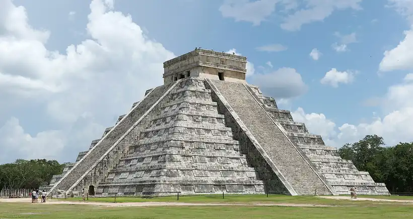

Chichén Itzá became the capital of the north between 900 and 1050. It traded by sea from its port on Isla Cerritos and was tied to its neighbours by more than 80 sacbeob, the white Maya causeways. As it declined, Mayapán took its place and led an alliance of northern lords from the 1220s until its fall around 1441. When the Spanish arrived, the north was divided among small Maya domains. The language endured. In 2020, 519,167 people in the state spoke Maya, and more than 98% of the state's Indigenous-language speakers used it.
Mérida on the stones of T'hó
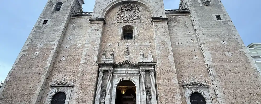
Francisco Hernández de Córdoba reached the coast on 1 Mar 1517, but the conquest took a generation. Francisco de Montejo failed in 1527-28 and again in 1531-35. His son, Montejo the Younger, founded Mérida on 6 Jan 1542 over the Maya city of T'hó and reused its carved stones for the first Spanish buildings, the cathedral among them, finished by 1598. Franciscan friars set their convent at Izamal on top of the Maya acropolis and completed it in 1561. On 12 Jul 1562, at Maní, Fray Diego de Landa burned Maya books and images in an auto de fe, a public ceremony of penance and punishment. Only a handful of Maya books survive today, which is why Maní is remembered.
Interactive maptap or click a state to open its page
From 1617 Yucatán was a captaincy general with wide practical autonomy, which many historians link to the separatism of the 1840s, though it stayed under the viceroy and the Audiencia. It reached over today's Campeche and Quintana Roo and, at times, Tabasco. Its wealth was cattle, salt and dyewood, and the cotton cloth (mantas) and beeswax taken from the Maya in tribute and through the repartimiento, the forced trade run by Spanish officials. From the 16th to the 18th century the haciendas were mostly cattle ranches that needed few hands. Maya resistance never ended. On 20 Nov 1761 Jacinto Canek led a rising against Spanish rule at Cisteil, in the south-centre of the state. It was put down within days. Canek was executed in Mérida, and in 1762 the village was burned and its ground salted.
Places in its history
Dzibilchaltún
Archaeological site · Preclassic-1500s
Long-lived city by the cenote Xlacah, with the Temple of the Seven Dolls. 12
A republic, the Caste War and green gold
Yucatán declared independence from Spain on 15 Sep 1821 and entered the federation as a founding state on 23 Dec 1823. When Mexico turned centralist, the state congress adopted an Act of Independence on 1 Oct 1841. In 1847 the Maya rose under Cecilio Chi and Jacinto Pat, driven by the loss of their communal lands to sugar estates and cattle ranches, heavy taxes and debt peonage, labour tied to the hacienda by debts that could never be paid off. The Caste War began in the east of the state and nearly overran the Yucatecan government, which in 1848 offered the peninsula's sovereignty to the USA, Britain and Spain in exchange for help. None took it up. Mexico sent money and arms on 14 Jul 1848, and the reunion was decreed on 17 Aug 1848.
1810 to 1920 in Yucatán
From the timeline below, coloured by era
- 1823Yucatán joins the Mexican federation on 23 Dec as a founding state. 2
- 1841-48The second Republic of Yucatán: Act of Independence on 1 Oct 1841; reunion with Mexico decreed on 17 Aug 1848. 21
- 1847The Caste War breaks out in the east of the state. 18
- 1872Progreso is founded as a port closer to Mérida than Sisal. 14
- 1902Porfirio Díaz creates the Territory of Quintana Roo from Yucatán's east on 24 Nov. 1
- 19051,033 Korean workers arrive for the henequen fields. 23
- 1916Mérida hosts Mexico's first feminist congress under Salvador Alvarado. 19
From 1850 the rebels of the southeast followed the Talking Cross at Chan Santa Cruz, which held out until federal troops took it in 1901. Estimates of the dead run from 40,000 to 200,000. Campeche broke away in 1857-58 and was admitted as a state on 29 Apr 1863. Quintana Roo was carved out in 1902, taking the Caribbean coast where Cancún would be built from 1970.
The war cleared the ground for henequen, whose fibre became the binder twine of the grain harvesters on the plains of the USA and Canada. Exports rose from 31,000 bales in 1873 to 1.2 million in 1915, and nearly 1,200 haciendas ringed Mérida, worked by Maya peons held by debt and, from 1905, by 1,033 Korean contract workers. A planter elite, which its critics called the casta divina, lined Mérida's Paseo de Montejo with mansions. Its best-known member, Olegario Molina, governor from 1902 to 1907, had his export house sign a secret contract with International Harvester in 1902 that pushed fibre prices down. On 4 Jun 1910, 1,500 people rose in arms in the east of the state, an uprising often called the first spark of the Revolution.
Salvador Alvarado, sent by Carranza and governor from 1915 to 1918, took charge of the Reguladora, the state's henequen marketing commission, made it the only body allowed to trade the fibre and began to roll back Molina's alliance with International Harvester. He cancelled the Maya workers' debts, set minimum wages and held the First Feminist Congress in Mérida in 1916. Felipe Carrillo Puerto, governor from 1 Feb 1922, spoke in Maya at his swearing-in and opened 417 schools in his first year. He was shot by firing squad in Mérida on 3 Jan 1924.
From ejido henequen to maquilas and Maya cities
Henequen held the economy for most of the century, but its market was slipping. The 1929 crash cut prices, and after the Second World War synthetic fibres began to replace it. On 3 Aug 1937 Lázaro Cárdenas arrived to lead the land reform in person from Mérida and turned the henequen haciendas into collective ejidos, communal farmland granted under the reform. In 1961 private investors founded Cordemex to run the cordage mills; that Dec the federal government took majority control, and the state company lasted until it was dissolved at the end of 1991. Old estates shut their rasping sheds one by one. Hacienda Yaxcopoil, a cattle ranch in the 1600s and a henequen estate of 12,000 hectares at its peak, made its last fibre in 1984.
The region, c. 1600 and today
What each state turned on, by the era table below; Yucatán outlined in gold.
Interactive maptap or click a state to open its page
c. 1600
Yucatán: Maya lands under encomienda or beyond Spanish rule
- Maya lands under encomienda or beyond Spanish rule
Today
Yucatán: Services and government
- Oil and gas
- Tourism
- Services and government
Isolation ended slowly. Seaplanes flew from Progreso to Havana and Florida in the 1930s, the railway joined the peninsula to central Mexico around 1950, and jet flights reached Mérida in the 1960s. From the 1980s the economy diversified, and by the 1990s the state had left its dependence on henequen behind. Export maquiladoras, assembly plants producing for foreign markets, mostly in textiles and clothing, came in, along with tourism to the old Maya cities. Chichén Itzá became a World Heritage Site in 1988 and Uxmal in 1996.
By the 2020 census Mérida's metropolitan area, which takes in Kanasín and Umán, held 1,316,090 people. In the 5 years before that census more than 120,000 people moved to Yucatán, led by arrivals from Quintana Roo, Campeche, Tabasco and Mexico City who were leaving crowded cities, high living costs or insecurity. Americans and Canadians came too, for family, housing or economic reasons, an estimated 11,000 of them living in Mérida by 2025, a city counted among the safest in Mexico. Mérida was American Capital of Culture in 2000 and again in 2017, the only city to hold the title twice.
Industrial pork farms spread: the peninsula's pork output grew 36% between 2006 and 2018, and its farms are cleared to export to China, Japan, Korea and the USA. Progreso's viaduct was extended to 6.5 km in 1985 to reach deeper water, and from 1999 its channel was dredged from 7.5 m to 12 m. The Tren Maya, whose first stretch opened on 15 Dec 2023 and whose full loop was finished on 15 Dec 2024, links Mérida, Izamal and Chichén Itzá with Campeche and Cancún. The state lives today on Mérida's services and industry, on tourism and on agribusiness, and it still speaks Maya.
Yucatán, date by date
Before the Spanish before 1519
- c. 750-200 BCE
Izamal is founded in the Late Formative and later becomes a great pilgrimage centre. 13
- c. 700
Uxmal is built, the leading city of the Puuc hills. 10
- 900-1050
Chichén Itzá reaches its height as capital of northern and central Yucatán. 9
- c. 1441
Mayapán, capital of the northern Maya since the 1220s, falls. 11
- 1517
Francisco Hernández de Córdoba's expedition reaches the coast on 1 Mar. 1
The colonial centuries 1519 to 1809
Independence and the Reform 1810 to 1875
- 1823
Yucatán joins the Mexican federation on 23 Dec as a founding state. 2
- 1841-48
The second Republic of Yucatán: Act of Independence on 1 Oct 1841; reunion with Mexico decreed on 17 Aug 1848. 21
- 1847
The Caste War breaks out in the east of the state. 18
- 1872
Progreso is founded as a port closer to Mérida than Sisal. 14
The Porfiriato 1876 to 1910
The Revolution 1910 to 1920
- 1916
Mérida hosts Mexico's first feminist congress under Salvador Alvarado. 19
Modern Mexico after 1920
- 1924
Governor Felipe Carrillo Puerto is shot by firing squad in Mérida on 3 Jan. 20
- 1937
Lázaro Cárdenas turns the henequen haciendas into collective ejidos. 2
- 1961
Private investors found Cordemex; in Dec the federal government takes majority control. 24
- 2023
The first stretch of the Tren Maya opens on 15 Dec, linking Mérida with Campeche and Cancún. 25
Where Yucatán stood: c. 1600, 1910 and today
Interactive maptap or click a state to open its page
c. 1600
Silver, the heartland and the frontier
Yucatán: Maya lands under encomienda or beyond Spanish rule
- Silver mining districts
- Towns, farms and workshops of the old heartland
- Ports, sugar and cacao
- Indigenous south: cochineal, maize, tribute
- Maya lands under encomienda or beyond Spanish rule
- Frontier: missions, presidios, independent peoples
1910
The Porfiriato at its height
Yucatán: Henequén
- Mining
- Oil
- Henequén
- Sugar and textile mills
- Haciendas: grain, pulque, cattle
- Export crops: coffee, tobacco, cacao, chicle, timber
- Steel, cotton and the railway north
- Ranching frontier
- The national capital
Today
What each state turns on now
Yucatán: Services and government
- Export manufacturing
- Oil and gas
- Tourism
- Farming and agro-exports
- Mining
- Ports and logistics
- Services and government
Why Mexico's own reading of what each state's economy turned on in that period, drawn from the sources listed in each state's room; a classification, not a measurement.
Today's numbers for Yucatán
Output, exports, jobs, wages and investment now, each with its source and date.
The bookBook 6, Where to Go in Mexico, chapter 19
Where to Go in Mexico: The Peninsula, the corridor this state belongs to.
Why MexicoThe national timeline
The turning points of the whole country, each dated, each with its source.
Sources, each with its date
- Wikipedia (English), Yucatán, History section, 3 Nov 2026 · read 3 Nov 2026 · link
- Wikipedia (Spanish), Yucatán, history and economy sections, 3 Nov 2026 · read 3 Nov 2026 · link
- Wikipedia (Spanish), Historia de Yucatán, 3 Nov 2026 · read 3 Nov 2026 · link
- Tercer Censo de Población 1910, Table VI, population by federal entity in 1895, 1900 and 1910 (digital copy, Universidad Veracruzana), 1910 · read 3 Nov 2026 · link
- INEGI, Censo de Población y Vivienda 2020, results for Yucatán (press bulletin), Jan 2021 · read 3 Nov 2026 · link
- INEGI, Censo 2020, presentation of results for Yucatán (Indigenous-language speakers aged 3+, 2010 and 2020), 2021 · read 3 Nov 2026 · link
- Posta, "¿Cuáles son las lenguas indígenas que se hablan en Yucatán?", speaker counts by language attributed to INEGI, 10 Mar 2024 · read 3 Nov 2026 · link
- Wikipedia (English), Mérida, Yucatán, 3 Nov 2026 · read 3 Nov 2026 · link
- Wikipedia (English), Chichen Itza, 3 Nov 2026 · read 3 Nov 2026 · link
- Wikipedia (English), Uxmal, 3 Nov 2026 · read 3 Nov 2026 · link
- Wikipedia (English), Mayapan, 3 Nov 2026 · read 3 Nov 2026 · link
- Wikipedia (English), Dzibilchaltun, 3 Nov 2026 · read 3 Nov 2026 · link
- Wikipedia (English), Izamal, 3 Nov 2026 · read 3 Nov 2026 · link
- Wikipedia (English), Progreso, Yucatán, 3 Nov 2026 · read 3 Nov 2026 · link
- Wikipedia (English), Henequen industry in Yucatán, 3 Nov 2026 · read 3 Nov 2026 · link
- Wikipedia (English), Haciendas of Yucatán, 3 Nov 2026 · read 3 Nov 2026 · link
- Wikipedia (Spanish), Hacienda Yaxcopoil, 3 Nov 2026 · read 3 Nov 2026 · link
- Wikipedia (English), Caste War of Yucatán, 3 Nov 2026 · read 3 Nov 2026 · link
- Wikipedia (English), Salvador Alvarado, 3 Nov 2026 · read 3 Nov 2026 · link
- Wikipedia (English), Felipe Carrillo Puerto, 3 Nov 2026 · read 3 Nov 2026 · link
- Wikipedia (English), Republic of Yucatán, 3 Nov 2026 · read 3 Nov 2026 · link
- Wikipedia (Spanish), Cisteil, 3 Nov 2026 · read 3 Nov 2026 · link
- Wikipedia (Spanish), Inmigración coreana en México, 3 Nov 2026 · read 3 Nov 2026 · link
- Wikipedia (Spanish), Cordemex, 3 Nov 2026 · read 3 Nov 2026 · link
- Wikipedia (English), Tren Maya, 3 Nov 2026 · read 3 Nov 2026 · link
- Wikipedia (English), Chicxulub crater, 3 Nov 2026 · read 3 Nov 2026 · link
- Gabriela Solís Robleda, "El repartimiento de géneros y la sociedad indígena en Yucatán en el siglo XVII", Estudios de Historia Novohispana (UNAM), 2000 · read 3 Nov 2026 · link
- Wikipedia (English), Campeche, 3 Nov 2026 · read 3 Nov 2026 · link
- Wikipedia (English), Cancún, 3 Nov 2026 · read 3 Nov 2026 · link
- Sterling Evans, Bound in Twine: The History and Ecology of the Henequen-Wheat Complex for Mexico and the American and Canadian Plains (Texas A&M University Press), Project MUSE description, 2007 · read 3 Nov 2026 · link
- Wikipedia (English), Olegario Molina, 3 Nov 2026 · read 3 Nov 2026 · link
- Robert D. Temple, "First Spark and Revolution", The Yucatán Times, 3 Nov 2026 · read 3 Nov 2026 · link
- Por Esto, "Uno de cada 10 habitantes de Yucatán nació en otro estado" (census data on migrants to Yucatán), 5 Apr 2026 · read 3 Nov 2026 · link
- Posta, "¿Cuántos estadounidenses viven en Yucatán?", 29 Jan 2025 · read 3 Nov 2026 · link
- Mexico News Daily, "Indigenous community calls for protective measures as pork industry grows", 7 Jul 2021 · read 3 Nov 2026 · link
- Administración Portuaria Integral de Progreso, history of the port, 3 Nov 2026 · read 3 Nov 2026 · link
Pictures
- Catedral de San Ildefonso, Mérida, Yucatán, fachada principal: Gideonximi, CC BY 4.0, Wikimedia Commons · read 3 Nov 2026
- Chichen Itza 3: Daniel Schwen, CC BY-SA 4.0, Wikimedia Commons · read 3 Nov 2026

Where the sources disagree
- Deaths in the Caste War: Wikipedia (English, Caste War of Yucatán) gives 40,000-50,000; Wikipedia (English, Yucatán) cites estimates of up to 200,000. This page gives the range 40,000 to 200,000.
- Railway link to central Mexico: Wikipedia (Spanish, Historia de Yucatán) gives 1950, Wikipedia (Spanish, Yucatán) gives 1951, and Wikipedia (English) says the 1950s. This page says around 1950.
- Road link to central Mexico: Wikipedia (English) and Wikipedia (Spanish, Historia) say the 1960s; Wikipedia (Spanish, Yucatán) says the 1980s. This page leaves the highway out.
- Speakers by language: the 2024 Posta article, based on INEGI, gives 519,167 for Maya and sums to INEGI's 2020 total of 525,092; DataMexico gives 528,563 for Maya. This page uses the Posta figures.
- Korean workers in 1905: Wikipedia (English, Yucatán) gives 1,003; Wikipedia (Spanish) gives about 1,033; Wikipedia (English, Koreans in Mexico) says more than 1,000. This page uses 1,033.
Veracruz
From the Olmec heads of San Lorenzo and the niches of El Tajín to the gateway port of New Spain, Yanga's free town and the oil of the Golden Lane.
All 32 on the mapNext →Zacatecas
From the turquoise traders of Chalchihuites to the silver city founded in 1546 and the battle of 1914, Zacatecas has fed Mexico's wealth and sent its people to the USA.