Oaxaca
From Monte Albán and the Mixtec kingdoms to cochineal, Juárez and Díaz, Oaxaca kept its peoples and its languages through every century.
Capital: Oaxaca de Juárez · Became a state: 1823 · Checked 3 Nov 2026
Interactive maptap or click a state to open its page
Oaxaca in figures from its history
Zapotec and Mixtec cities of the valleys and the Mixteca
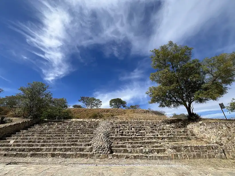
Mountains split Oaxaca into isolated valleys, and that is why it kept 16 Indigenous languages, the number of ethnolinguistic groups the Instituto Nacional Indigenista recognised. Its 8 official regions are the Valles Centrales, Cañada, Mixteca, Sierra Sur, Sierra Norte, Istmo, Costa and Papaloapan (Cuenca). The Central Valleys hold some of the oldest farming in the Americas. The cave of Guilá Naquitz, near Mitla, preserves early evidence of domesticated plants, and by about 2000 BCE farmers lived in settled villages. San José Mogote, in the Etla valley, was the first great Zapotec centre. Around 500 BCE the Zapotecs built Monte Albán on a ridge above the valleys, a capital that dominated the region for more than a thousand years, with an estimated 17,000 to 40,000 people at its height. It was largely abandoned by about 900 to 1000 CE.
Indigenous languages spoken today
Speakers aged 3 and over, census of 2020 1718
In all, 1,221,555 people aged 3 and over spoke an Indigenous language in 2020, 31.2% of that age group. Chinantec, Chatino, Triqui, Ikoots (Huave), Cuicatec, Chontal, Zoque, Amuzgo, Chocholtec and Ixcatec are also spoken.

Power then passed to smaller kingdoms. Mitla, its walls covered in stone fretwork fitted without mortar, became the main Zapotec religious centre. In the Mixteca, lords ruled from Achiutla, Apoala, Coixtlahuaca, Teposcolula and Tilantongo, and from Tilantongo, his seat, Lord 8 Deer Jaguar Claw (1063-1115) began to join their city-states together. Mixtecs later reused Monte Albán's tombs, Tomb 7 above all: when Alfonso Caso opened it in 1932 he found a Mixtec burial full of gold work and jewels. The Aztecs pushed in from 1457 and placed a garrison on the hill of Huaxyácac in 1486. Zapotec and Mixtec are still the most spoken languages in the state, beside Mazatec, Mixe (Ayuuk), Chinantec, Chatino, Triqui, Chontal, Ixcatec and others.
Friars, the Marquesado and the red of cochineal
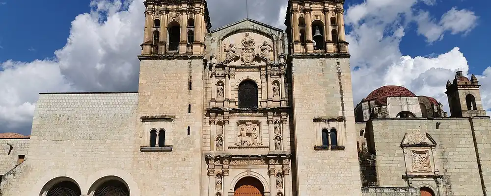
Spanish captains, among them Francisco de Orozco, reached the valleys soon after the fall of Tenochtitlan, and Huaxyácac fell in Dec 1521. The Mixe of the Sierra Norte resisted Spanish conquest for decades and were never fully subdued; after a rising in 1570 they withdrew deeper into the mountains. Hernán Cortés became Marquis of the Valley of Oaxaca, a title that gave him personally the land and tribute of the valley's towns. The Spanish town of Antequera was re-established in 1529 and won a royal city charter in 1532. Dominicans arrived in 1528, and their convent of Santo Domingo became the religious heart of the region. The Bishopric of Antequera was erected on 21 Jun 1535; its first bishop, Juan López de Zárate, served until 1555. Disease and war were devastating: by estimate, the native population fell from about 1.5 million in 1520 to 150,000 by 1650. The Spanish also brought enslaved Africans, mostly to the Costa Chica.
Interactive maptap or click a state to open its page
Oaxaca had few mines of note, so its wealth came from a living dye. Cochineal, a red obtained from a small insect, was produced by Indigenous households and became New Spain's most valuable export after silver, shipped to Europe above all in the 17th and 18th centuries. The trade ran through the repartimiento de mercancías: the alcaldes mayores, the Crown's district officials, backed by merchants, forced credit and goods on villages and collected the dye in payment, a system that trapped many households in debt. In the Valley of Oaxaca, Indigenous communities and the Indigenous nobility kept most of the land, and Spanish haciendas, large landed estates, never dominated as they did in the north (William B. Taylor, Landlord and Peasant in Colonial Oaxaca, 1972). After Independence, Guatemala and the Canary Islands broke the Mexican monopoly on cochineal, and from the middle of the 19th century artificial dyes took most of its market.
Places in its history
Oaxaca de Juárez
City · 1529
The capital, founded as Antequera and renamed Oaxaca in 1821; "de Juárez" was added in 1872. 3
Monte Albán
Archaeological site · c. 500 BCE-1000 CE
Zapotec capital on a ridge above the valleys; its Tomb 7 held a Mixtec treasure. 4
Guelatao de Juárez
City · Birthplace of Benito Juárez, 1806
Zapotec village of the Sierra Norte, once San Pablo Guelatao. 9
Huajuapan de León
Battlefield · 1812
Insurgents under Valerio Trujano held out here for 111 days until Morelos broke the siege. 8
Teposcolula
Archaeological site · c. 700-1521
One of the Mixtec seats of power in the Mixteca Alta. 10
Morelos, Juárez, Díaz and the Sovereignty
Oaxaca's government stayed loyal to the Crown in 1810. In 1812 Valerio Trujano's insurgents held out in a siege of 111 days at Huajuapan until Morelos came to their aid, and on 25 Nov 1812 Morelos took the city of Oaxaca. Royalists retook it on 29 Mar 1814. The state was created on 21 Dec 1823 and issued its first constitution on 10 Jan 1825. Benito Juárez, a Zapotec from Oaxaca born in Guelatao in 1806, became Mexico's most revered president. He was governor of the state from 1847 and later led the Reform, the liberal laws of the 1850s and 1860s that sold off Church and communal lands, and the republic's fight against the French. French troops invaded the state in 1864 and took the capital on 9 Feb 1865, when Porfirio Díaz surrendered it. Díaz came back, defeated an imperial relief army at La Carbonera on 18 Oct 1866, and the republic recovered the city soon after.
1810 to 1920 in Oaxaca
From the timeline below, coloured by era
- 1812Morelos takes the city of Oaxaca on 25 Nov 1812. 7
- 1823The state of Oaxaca is created on 21 Dec 1823. 2
- 1865French troops take the city of Oaxaca on 9 Feb 1865, when Porfirio Díaz surrenders it. 21
- 1876Porfirio Díaz takes power through the revolt of Tuxtepec. 2
- 1892The Mexican Southern Railroad reaches the capital in Nov 1892. 11
- 1907The Tehuantepec Railway and the port of Salina Cruz open on 23 Jan 1907. 22
- 1915On 3 Jun 1915 the legislature declares that Oaxaca reassumes its sovereignty. 14
Díaz, also from Oaxaca, rose with the revolt of Tuxtepec in 1876 and dominated Mexico until 1911, the years called the Porfiriato. The Mexican Southern Railroad reached the capital from Puebla in Nov 1892, and on 23 Jan 1907 the Tehuantepec Railway opened across the Isthmus with the ports of Salina Cruz and Coatzacoalcos, a route between the oceans that lost its trade once the Panama Canal opened in 1914. Most gains went to large estates and companies; federal and state incentives spread coffee in the mountains, and the tobacco plantations of Valle Nacional became a byword for forced labour, as John Kenneth Turner reported in Barbarous Mexico (1910). The Oaxacan Flores Magón brothers founded the newspaper Regeneración against Díaz. In the Revolution, Oaxacan elites rejected Carranza's government, and on 3 Jun 1915 the legislature declared that Oaxaca reassumed its sovereignty. The Carrancistas, Carranza's Constitutionalist troops, took the capital in Mar 1916; the sovereigntists held out until 1920, and a new state constitution came in 1922.
Ejidos, highways, Huatulco and the road north
Oaxaca entered the 20th century as a land of villages. Farming stayed the largest activity, mostly on ejidos, farmland granted to communities under the land reform, and on communal land, though only about 9% of the state is suited to crops. After the earthquake of 1931, leaders recast the Guelaguetza, the old festival of the Lunes del Cerro held on the Cerro del Fortín, as a statewide celebration to lift the region's spirits. In the 1940s and 1950s the Pan-American Highway crossed the state, and the Miguel Alemán Dam, begun in 1949 and opened in 1954, forced thousands of Mazatec, Chinantec and Mixe families off their land.
The region, c. 1600 and today
What each state turned on, by the era table below; Oaxaca outlined in gold.
Interactive maptap or click a state to open its page
c. 1600
Oaxaca: Indigenous south: cochineal, maize, tribute
- Silver mining districts
- Towns, farms and workshops of the old heartland
- Ports, sugar and cacao
- Indigenous south: cochineal, maize, tribute
Today
Oaxaca: Tourism
- Export manufacturing
- Oil and gas
- Tourism
- Farming and agro-exports
- Services and government
Rugged mountains, little farmland, small communal plots and few jobs sent Oaxacans north, first to other states and then to the USA, above all California and Illinois; migration has cut the population of 45.5% of the state's municipalities. Tourism grew from the 1980s. FONATUR, the federal tourism fund, began the resort of Bahías de Huatulco in 1984, UNESCO listed Monte Albán and the historic centre of Oaxaca in 1987, and by 2000 the state counted 612 hotels and 1,564,936 visitors. The Oaxaca-Mexico City highway was built in 1994. Mezcal, about 90% of the country's output, and crafts are part of the state's real economy.
In 2006 the strike of the teachers' Section 22 gave rise to the APPO and months of clashes in the capital, with at least 17 deaths, ending with a federal police intervention. In the Isthmus, the wind through the Chivela pass drew most of Mexico's wind farm projects to La Ventosa (18 of 27), and several brought land conflicts with Zapotec (binnizá) and Ikoots communities; in 2013 the Mareña Renovables park was withdrawn in the face of their opposition. The earthquake of 7 Sep 2017 devastated Juchitán and the Isthmus. The Interoceanic Corridor, created on 14 Jun 2019, rebuilt the 1907 line between ports 303 km apart and opened passenger service on 22 Dec 2023. On 28 Dec 2025 a train derailed near Nizanda, with 13 dead.
Of the 570 municipalities, 418 rule themselves by usos y costumbres, community assemblies and customary law, and on 9 Aug 2019 the federal constitution recognised Afro-Mexican peoples, among them those of the Costa Chica. The mountains that sheltered Oaxaca's peoples and languages also kept it apart from the country's investment, and the old route between the oceans is again its project for the future.
Oaxaca, date by date
Before the Spanish before 1519
The colonial centuries 1519 to 1809
Independence and the Reform 1810 to 1875
The Porfiriato 1876 to 1910
The Revolution 1910 to 1920
- 1915
On 3 Jun 1915 the legislature declares that Oaxaca reassumes its sovereignty. 14
Modern Mexico after 1920
Where Oaxaca stood: c. 1600, 1910 and today
Interactive maptap or click a state to open its page
c. 1600
Silver, the heartland and the frontier
Oaxaca: Indigenous south: cochineal, maize, tribute
- Silver mining districts
- Towns, farms and workshops of the old heartland
- Ports, sugar and cacao
- Indigenous south: cochineal, maize, tribute
- Maya lands under encomienda or beyond Spanish rule
- Frontier: missions, presidios, independent peoples
1910
The Porfiriato at its height
Oaxaca: Export crops: coffee, tobacco, cacao, chicle, timber
- Mining
- Oil
- Henequén
- Sugar and textile mills
- Haciendas: grain, pulque, cattle
- Export crops: coffee, tobacco, cacao, chicle, timber
- Steel, cotton and the railway north
- Ranching frontier
- The national capital
Today
What each state turns on now
Oaxaca: Tourism
- Export manufacturing
- Oil and gas
- Tourism
- Farming and agro-exports
- Mining
- Ports and logistics
- Services and government
Why Mexico's own reading of what each state's economy turned on in that period, drawn from the sources listed in each state's room; a classification, not a measurement.
Today's numbers for Oaxaca
Output, exports, jobs, wages and investment now, each with its source and date.
The bookBook 6, Where to Go in Mexico, chapter 20
Where to Go in Mexico: The Deep South: Guerrero, Oaxaca and Chiapas, the corridor this state belongs to.
Why MexicoThe national timeline
The turning points of the whole country, each dated, each with its source.
Sources, each with its date
- Wikipedia (English), Oaxaca, History section, 3 Nov 2026 · read 3 Nov 2026 · link
- Wikipedia (Spanish), Oaxaca, history section, 3 Nov 2026 · read 3 Nov 2026 · link
- Wikipedia (English), Oaxaca City, 3 Nov 2026 · read 3 Nov 2026 · link
- Wikipedia (English), Monte Albán, 3 Nov 2026 · read 3 Nov 2026 · link
- Wikipedia (English), Mitla, 3 Nov 2026 · read 3 Nov 2026 · link
- Wikipedia (English), Cochineal, 3 Nov 2026 · read 3 Nov 2026 · link
- Wikipedia (English), Capture of Oaxaca (1812), 3 Nov 2026 · read 3 Nov 2026 · link
- Wikipedia (English), Huajuapan de León, 3 Nov 2026 · read 3 Nov 2026 · link
- Wikipedia (English), Guelatao de Juárez, 3 Nov 2026 · read 3 Nov 2026 · link
- Wikipedia (English), San Pedro y San Pablo Teposcolula, 3 Nov 2026 · read 3 Nov 2026 · link
- Wikipedia (English), Mexican Southern Railroad, 3 Nov 2026 · read 3 Nov 2026 · link
- Wikipedia (English), Huatulco, 3 Nov 2026 · read 3 Nov 2026 · link
- INAH, Museo de Sitio de Monte Albán (lugares.inah.gob.mx), 3 Nov 2026 · read 3 Nov 2026 · link
- Paul Garner, 'Federalism and caudillismo in the Mexican Revolution: the genesis of the Oaxaca sovereignty movement (1915-20)', Journal of Latin American Studies 17(1), abstract, May 1985 · read 3 Nov 2026 · link
- The Statesman's Year-Book 1913, Mexico, table of states with 1900 and 1910 census populations (Wikisource transcription), 1913 · read 3 Nov 2026 · link
- INEGI, Censo de Población y Vivienda 2020, results for Oaxaca, press release, 26 Jan 2021 · read 3 Nov 2026 · link
- Aire Libre Oaxaca, report on Indigenous-language speakers citing INEGI 2020 census figures by language, 21 Feb 2025 · read 3 Nov 2026 · link
- Julio César Gallardo Vásquez, Colmix, 'Población y lengua mixe en el Censo 2020', May 2021 · read 3 Nov 2026 · link
- Wikipedia (English), Roman Catholic Archdiocese of Antequera, Oaxaca; and Wikipedia (Spanish), Arquidiócesis de Antequera, 3 Nov 2026 · read 3 Nov 2026 · link
- Wikipedia (English), Battle of La Carbonera, 3 Nov 2026 · read 3 Nov 2026 · link
- Archivo del general Porfirio Díaz: Memorias y documentos, vol. 2, ch. 44, 'Rendición de Oaxaca' (UNAM, Instituto de Historia, 1947), 1947 · read 3 Nov 2026 · link
- Wikipedia (English), Interoceanic Corridor of the Isthmus of Tehuantepec, 3 Nov 2026 · read 3 Nov 2026 · link
- Wikipedia (English), Guelaguetza, 3 Nov 2026 · read 3 Nov 2026 · link
- Diario Oficial de la Federación, 9 Aug 2019: decree adding section C to Article 2 of the Constitution (copy held by the Supreme Court, SCJN), 9 Aug 2019 · read 3 Nov 2026 · link
- Wikipedia (English), Eight Deer Jaguar Claw, 3 Nov 2026 · read 3 Nov 2026 · link
- William B. Taylor, Landlord and Peasant in Colonial Oaxaca (Stanford University Press, 1972), publisher description; and Wikipedia (English), William B. Taylor (historian), 1972 · read 3 Nov 2026 · link
- Historia Mexicana (El Colegio de México), "Taxation and Mexican Coffee. The Porfiriato's Strategies for Promoting Coffee Production and Sale (1870-1910)", abstract, 3 Nov 2026 · read 3 Nov 2026 · link
- John Kenneth Turner, Barbarous Mexico (1910), chapter 5 (Wikisource), 1910 · read 3 Nov 2026 · link
- Wikipedia (English), Miguel Alemán Dam, 3 Nov 2026 · read 3 Nov 2026 · link
- Wikipedia (English), Mezcal, 3 Nov 2026 · read 3 Nov 2026 · link
- Wikipedia (English), 2006 Oaxaca protests, 3 Nov 2026 · read 3 Nov 2026 · link
- Wikipedia (English), Wind power in Mexico, 3 Nov 2026 · read 3 Nov 2026 · link
- La Jornada, "Un triunfo de los pueblos, la cancelación del proyecto: asamblea", 3 Feb 2014, 3 Feb 2014 · read 3 Nov 2026 · link
- Wikipedia (English), Juchitán de Zaragoza; and Wikipedia (English), 2017 Chiapas earthquake, 3 Nov 2026 · read 3 Nov 2026 · link
- El Financiero, "Descarrilamiento del Tren Interoceánico deja 13 muertos y 98 heridos", 28 Dec 2025, 28 Dec 2025 · read 3 Nov 2026 · link
Pictures
- Templo de Santo Domingo de Guzmán, Oaxaca-2: Nanahuatl, CC BY-SA 4.0, Wikimedia Commons · read 3 Nov 2026
- Monte Albán aspectos 04: WendyAvilesR, CC BY 4.0, Wikimedia Commons · read 3 Nov 2026

Where the sources disagree
- Statehood of Oaxaca: Wikipedia (Spanish) and the Wikipedia (English) infobox give 21 Dec 1823; the English text gives 1824, when the first governor was named. This page uses 21 Dec 1823.
- Monte Albán at its height: Wikipedia (English, Monte Albán) gives about 17,200 people, Wikipedia (English, Oaxaca) about 25,000, Wikipedia (Spanish) about 40,000. This page gives a range of 17,000 to 40,000.
- Founding of Monte Albán: Wikipedia (English) gives c. 500 BCE; Wikipedia (Spanish) gives 500-100 BCE. This page uses c. 500 BCE.
- Indigenous peoples of Oaxaca: Wikipedia (English) gives 16 ethnolinguistic groups recognised by the Instituto Nacional Indigenista; Wikipedia (Spanish) gives 18 ethnic groups. This page uses 16.
Nuevo León
From the carved rocks of desert hunters to the foundries and breweries of Monterrey, Nuevo León turned a poor frontier kingdom into Mexico's industrial north.
All 32 on the mapNext →Puebla
From early maize at Tehuacán and the pyramid of Cholula to the City of the Angels, the battle of 5 May 1862, textile mills and Volkswagen.