Puebla
From early maize at Tehuacán and the pyramid of Cholula to the City of the Angels, the battle of 5 May 1862, textile mills and Volkswagen.
Capital: Puebla · Became a state: 1824 · Checked 3 Nov 2026
Interactive maptap or click a state to open its page
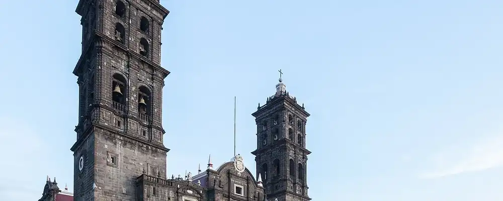
Puebla in figures from its history
Maize, Cholula and the cities of the plateau
The dry caves of the Tehuacán Valley hold some of the longest records of human life in Mexico. Richard MacNeish dug there from 1960 to 1965 and found more than 10,000 early cobs at Coxcatlán Cave; the oldest maize from the valley is dated to about 3600 BCE, though later research points to the Balsas basin, to the southwest, as the first home of maize. By 900 BCE farmers on the Puebla plateau grew maize, beans, squash, chile and cotton.
Indigenous languages spoken today
Speakers aged 3 and over, census of 2020 5
615,622 people aged 3 and over spoke an Indigenous language in 2020 (9.9%). Otomí follows closely after Mixtec, with 8,162 speakers.
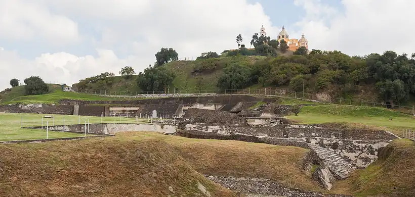

Cholula grew into a great pilgrim city of Quetzalcoatl. Its pyramid, built in stages from the 3rd century BCE to the 9th century CE, is the largest in the world by volume. In the east, Cantona, on the road to the Gulf coast, flourished between 600 and 1000 CE and traded obsidian from nearby mountains. In the Sierra Norte, Yohualichan shared the culture of El Tajín, and in the south Tepexi el Viejo was the seat of a Popoloca lordship from 1200 to 1500. By the 15th century much of the region paid tribute to the Mexica. Five peoples still carry their own languages here: Nahuas, Totonacs, Mazatecs, Popolocas and Mixtecs, with Nahuatl spoken by more than 450,000 people.
The City of the Angels on the road to the sea
Cortés crossed the region in 1519 on his way to Tlaxcala, and in Oct 1519 his troops carried out the massacre of Cholula. After the retreat from Tenochtitlan he founded a Spanish post at Tepeaca in 1520. The friars came next. Franciscans founded the monastery of Huejotzingo in 1525 and built the present complex between 1544 and 1570, one of the monasteries on the slopes of Popocatépetl now listed as World Heritage.
Interactive maptap or click a state to open its page
Puebla de los Ángeles was founded on 16 Apr 1531, a Spanish city laid out to secure the road between Mexico City and the port of Veracruz. A flood forced a move across the river in 1532. It became the second city of New Spain, feeding the capital with wheat and flour. Its workshops turned out glass from 1542, woollens and cotton cloth in the obrajes, the colony's textile workshops, and Talavera pottery, made by potters from Talavera de la Reina who arrived between 1550 and 1570; its golden age ran from 1650 to 1750. Indigenous towns did most of the work, and around 1810 roughly 74% of the people of Puebla still spoke an Indigenous language.
Places in its history
Great Pyramid of Cholula
Archaeological site · 3rd century BCE-9th century CE
The largest pyramid by volume, crowned by a church built in 1594. 7
Tehuacán Valley
Archaeological site · c. 3600 BCE; 1660; 1994
Caves with some of the oldest maize, later a city of mineral springs and jeans maquilas. 10
Huejotzingo
Mission · 1525; 1544-70
Franciscan monastery of San Miguel, a World Heritage monastery of Popocatépetl. 11
Yohualichan
Archaeological site · Classic period
Totonac city of the Sierra Norte, kin to El Tajín. 12
Mills, forts and the 5th of May
The city of Puebla stayed loyal to the viceroy during the war of Independence, while insurgents held much of the south, around Izúcar and the Mixteca, and José Francisco Osorno led the rising in the Sierra Norte from 1811. Puebla became a free state on 23 Dec 1823 and entered the federation under the 1824 Constitution. Building on its colonial workshops, it industrialised early. In 1831 the first mechanized textile mill opened, and 17 more followed in the city. In 1847, during the war with the USA, invading troops took the city and stayed until the end of the war.
1810 to 1920 in Puebla
From the timeline below, coloured by era
- 1811José Francisco Osorno leads the insurgency in the Sierra Norte. 2
- 1823Puebla becomes a free state on 23 Dec. 2
- 1831The first mechanized textile mill opens. 1
- 1862Mexican troops defeat the French army at Puebla on 5 May. 13
- 1863The French take Puebla on 17 May. 13
- 1873The Puebla-Veracruz railway is completed. 1
- 1910The attack on the Serdán house on 18 Nov opens the Revolution in Puebla. 2
- 1920Venustiano Carranza is killed at Tlaxcalantongo, in the Sierra Norte. 1
On 5 May 1862 some 3,791 Mexican troops under Ignacio Zaragoza held the forts of Loreto and Guadalupe against 5,730 French soldiers, a victory still celebrated across Mexico and among Mexicans in the USA. The French returned and took the city on 17 May 1863, and were driven from the state in 1867. During the Porfiriato, Porfirio Díaz's rule of 1876-1911, the Puebla-Veracruz railway was finished in 1873 and a hydroelectric plant rose at Necaxa in 1907, as strikes spread among mill workers. On 18 Nov 1910 police and troops attacked the house of the Serdán family, an opening shot of the Revolution. The Zapatistas, the peasant army of Emiliano Zapata, then held much of the state.
Cars, jeans and the road north
After the Revolution, Puebla was re-founded in 1917 with 222 municipalities, and the 1920s were years of unstable government. One of the last clashes of the armed struggle took place at Aljibes in May 1920, and Venustiano Carranza was killed soon after at Tlaxcalantongo, in the Sierra Norte. Textile mills remained the backbone of the capital's economy until a new industry arrived. Volkswagen de México was founded in 1964, and the first car rolled off its Puebla line in 1967. The plant grew to 3,000,000 m², and Beetles were built there until 2003.
The region, c. 1600 and today
What each state turned on, by the era table below; Puebla outlined in gold.
Interactive maptap or click a state to open its page
c. 1600
Puebla: Towns, farms and workshops of the old heartland
- Silver mining districts
- Towns, farms and workshops of the old heartland
- Ports, sugar and cacao
- Indigenous south: cochineal, maize, tribute
Today
Puebla: Export manufacturing
- Export manufacturing
- Oil and gas
- Tourism
- Farming and agro-exports
- Services and government
Between 1962 and 1981 students, street vendors, Volkswagen workers and teachers led a series of popular and labour movements. In 1987 the historic centre of Puebla became a World Heritage Site. In the south, Tehuacán, known since the late 19th century for its mineral springs, filled with maquiladoras, export assembly plants sewing jeans, once the North American Free Trade Agreement (NAFTA) opened the USA market in 1994; more than 700 maquilas operated at the peak, and the city grew from about 150,000 to 360,000 people in a decade before many of them closed. Mixtec villages of the south lost people to Mexico City, northern Mexico and the USA.
Volkswagen kept building in the capital after the last Beetle in 2003, and on 30 Sep 2016 Audi opened its plant at San José Chiapa, in the east of the state; by 2021 it made the Q5 for every market except China, with the USA as its main customer. The Arco Norte toll road, open since 2009, lets that traffic bypass Mexico City. On 19 Sep 2017 a magnitude 7.1 earthquake struck with its epicentre near San Juan Raboso, in the south of the state; church towers fell in Cholula, and a church collapsed at Atzitzihuacan. The city founded to guard the road between the capital and the sea still lives by the road, now carrying cars to the north.
Puebla, date by date
Before the Spanish before 1519
The colonial centuries 1519 to 1809
Independence and the Reform 1810 to 1875
- 1811
José Francisco Osorno leads the insurgency in the Sierra Norte. 2
- 1823
Puebla becomes a free state on 23 Dec. 2
- 1831
The first mechanized textile mill opens. 1
- 1862
Mexican troops defeat the French army at Puebla on 5 May. 13
- 1863
The French take Puebla on 17 May. 13
- 1873
The Puebla-Veracruz railway is completed. 1
The Revolution 1910 to 1920
Modern Mexico after 1920
- 1967
The first Volkswagen rolls off the Puebla line. 14
- 1987
The historic centre of Puebla becomes a World Heritage Site. 6
- 1994
After NAFTA, jeans maquilas spread through Tehuacán. 10
- 2016
Audi opens its plant at San José Chiapa on 30 Sep 2016. 15
- 2017
A magnitude 7.1 earthquake strikes the south of the state on 19 Sep 2017. 17
Where Puebla stood: c. 1600, 1910 and today
Interactive maptap or click a state to open its page
c. 1600
Silver, the heartland and the frontier
Puebla: Towns, farms and workshops of the old heartland
- Silver mining districts
- Towns, farms and workshops of the old heartland
- Ports, sugar and cacao
- Indigenous south: cochineal, maize, tribute
- Maya lands under encomienda or beyond Spanish rule
- Frontier: missions, presidios, independent peoples
1910
The Porfiriato at its height
Puebla: Sugar and textile mills
- Mining
- Oil
- Henequén
- Sugar and textile mills
- Haciendas: grain, pulque, cattle
- Export crops: coffee, tobacco, cacao, chicle, timber
- Steel, cotton and the railway north
- Ranching frontier
- The national capital
Today
What each state turns on now
Puebla: Export manufacturing
- Export manufacturing
- Oil and gas
- Tourism
- Farming and agro-exports
- Mining
- Ports and logistics
- Services and government
Why Mexico's own reading of what each state's economy turned on in that period, drawn from the sources listed in each state's room; a classification, not a measurement.
Today's numbers for Puebla
Output, exports, jobs, wages and investment now, each with its source and date.
The bookBook 6, Where to Go in Mexico, chapter 16
Where to Go in Mexico: The Center, the corridor this state belongs to.
Why MexicoThe national timeline
The turning points of the whole country, each dated, each with its source.
Sources, each with its date
- Wikipedia (English), Puebla (state), History and Demographics sections, 3 Nov 2026 · read 3 Nov 2026 · link
- Wikipedia (Spanish), Estado de Puebla, Historia and Demografía sections, 3 Nov 2026 · read 3 Nov 2026 · link
- INEGI / 1910 census, Table VI, population of the federal entities in 1895, 1900 and 1910 (Universidad Veracruzana transcription), 1910 · read 3 Nov 2026 · link
- INEGI, 2020 Census main results for Puebla, press release 50/21, 26 Jan 2021 · read 3 Nov 2026 · link
- COESPO Puebla, Indigenous-language speakers by language, from the 2020 Census (Cuadro 1), Nov 2023 · read 3 Nov 2026 · link
- Wikipedia (English), Puebla (city), 3 Nov 2026 · read 3 Nov 2026 · link
- Wikipedia (English), Great Pyramid of Cholula, 3 Nov 2026 · read 3 Nov 2026 · link
- Wikipedia (English), Cantona (Mesoamerican site), 3 Nov 2026 · read 3 Nov 2026 · link
- INAH, Zona arqueológica de Cantona (location map), 3 Nov 2026 · read 3 Nov 2026 · link
- Wikipedia (English), Tehuacán, 3 Nov 2026 · read 3 Nov 2026 · link
- Wikipedia (English), Huejotzingo, 3 Nov 2026 · read 3 Nov 2026 · link
- Wikipedia (English), Yohualichan, 3 Nov 2026 · read 3 Nov 2026 · link
- Wikipedia (English), Battle of Puebla, 3 Nov 2026 · read 3 Nov 2026 · link
- Wikipedia (English), Volkswagen de México, 3 Nov 2026 · read 3 Nov 2026 · link
- Audi MediaCenter, 'Future is an attitude: Audi México celebrates five years of production in San José Chiapa' (press release, 2021), 2021 · read 3 Nov 2026 · link
- Wikipedia (English), Arco Norte, 3 Nov 2026 · read 3 Nov 2026 · link
- Wikipedia (English), 2017 Puebla earthquake, 3 Nov 2026 · read 3 Nov 2026 · link
Pictures
- Catedral de Puebla, México, 2013-10-11, DD 04: Diego Delso, CC BY-SA 3.0, Wikimedia Commons · read 3 Nov 2026
- Gran Pirámide de Cholula, Puebla, México, 2013-10-12, DD 04: Diego Delso, CC BY-SA 3.0, Wikimedia Commons · read 3 Nov 2026

Where the sources disagree
- Massacre of Cholula: Wikipedia (English, Puebla) gives 12 Oct 1519; Wikipedia (Spanish, Estado de Puebla) gives 18 Oct. This page says Oct 1519.
- Population around 1900: Wikipedia (Spanish) says about 1.3 million; the 1900 census (Table VI of the 1910 census) gives 1,021,133. This page uses the census figure.
- Oldest maize: Wikipedia (English, Puebla) gives c. 1500 BCE for the oldest sample; Wikipedia (English, Tehuacán) about 3600 BCE; Wikipedia (Spanish) 6500-2500 BCE. This page uses c. 3600 BCE.
- Troops at the Battle of Puebla: Wikipedia (English) gives 3,791 Mexican and 5,730 French soldiers; its Puebla article says about 6,000 French. This page uses 3,791 and 5,730.
- Epicentre of the 2017 earthquake: the USGS gives 5 km east-north-east of San Juan Raboso, Puebla; Wikipedia (English) also gives 12 km south-east of Axochiapan, Morelos. This page uses San Juan Raboso.
Oaxaca
From Monte Albán and the Mixtec kingdoms to cochineal, Juárez and Díaz, Oaxaca kept its peoples and its languages through every century.
All 32 on the mapNext →Querétaro
From Sierra Gorda cinnabar miners to the 1810 conspiracy, the fall of an empire and the 1917 Constitution, Querétaro has joined Mexico's centre to its north.