Veracruz
From the Olmec heads of San Lorenzo and the niches of El Tajín to the gateway port of New Spain, Yanga's free town and the oil of the Golden Lane.
Capital: Xalapa · Became a state: 1823 · Checked 3 Nov 2026
Interactive maptap or click a state to open its page
Veracruz in figures from its history
Olmec heads, Totonac cities and the Huasteca
The south of Veracruz was a cradle of the Olmec world. San Lorenzo Tenochtitlán, on high ground in the Coatzacoalcos basin, was the largest city in Mesoamerica from about 1200 to 900 BCE and the first Olmec site to show the marks of a state. Its sculptors carved colossal heads up to 3 m high from basalt hauled from the Tuxtla Mountains. Tres Zapotes was another key centre, and by 300 BCE the Olmec had been eclipsed by newer powers.
Indigenous languages spoken today
Speakers aged 3 and over, census of 2020 14
In all, 663,503 people aged 3 and over spoke an Indigenous language in 2020, 8.6% of that age group. Counts by language come from Data México, built on the same census. Popoluca languages are also spoken in the south.
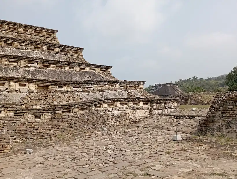

In the north, El Tajín flourished from about 600 to 1200 CE, with its peak around 900 to 1100. Its Pyramid of the Niches has 365 niches, one for each day of the year, and the city had at least 17 ballcourts; UNESCO listed it in 1992. The Totonacs held the land between the Cazones and Papaloapan rivers and at the Spanish arrival numbered about 250,000 people in some 50 towns. Their capital, Cempoala, had perhaps 25,000 to 30,000 people. The Huastecs held the far north, at their height between 1200 and 1519, and from the 15th century Aztec rulers turned much of the coast into tribute provinces. Nahuatl, Totonac and Tének (Huastec) are still the state's largest Indigenous languages.
The port of New Spain, sugar and Yanga's free town
Juan de Grijalva reached San Juan de Ulúa in 1518. In 1519 Hernán Cortés founded the Villa Rica de la Vera Cruz, one of the first Spanish town councils on the American mainland, and won as allies against the Aztecs the Totonacs of Cempoala, who paid tribute to them. At Cempoala, on 27 May 1520, he defeated the rival expedition of Pánfilo de Narváez. Epidemics followed. A smallpox outbreak in 1575-77 emptied Cempoala, and its survivors moved to Xalapa.
Interactive maptap or click a state to open its page
For about three centuries Veracruz was the monopoly port of the Carrera de Indias, the convoy system that carried all trade between Spain and its American colonies. Silver and cochineal, a red dye made from insects, left for Spain, and the fortress of San Juan de Ulúa, built between 1535 and 1769, guarded the harbour; there in 1568 Spanish forces trapped the English fleet of John Hawkins. Córdoba, Orizaba and Xalapa grew to protect the road to Mexico City, and Xalapa held its first trade fair in 1720. Sugar cane brought from the Caribbean needed labour, and enslaved Africans arrived from the 16th century. Gaspar Yanga led runaways, escaped from the sugar estates, into the highlands from about 1570, fought off Spanish troops in 1609 and in 1618 won freedom and a town of their own, San Lorenzo de los Negros, today Yanga.
Places in its history
Xalapa
City · c. 1313; capital 1885
State capital since 1885; once a Totonac town and a colonial trade-fair town. 9
El Tajín
Archaeological site · c. 600-1200
City of the Pyramid of the Niches; UNESCO World Heritage, 1992. 4
San Juan de Ulúa
Fort · 1535-1825
Island fortress guarding the port of New Spain; the last Spanish stronghold, surrendered in 1825. 7
Fortress, sieges and the gateway for invaders
Spanish troops held San Juan de Ulúa after 1821 and gave it up only in Nov 1825. Veracruz was admitted as a state on 22 Dec 1823 and reached its final shape in 1853, when Tuxpan and Chicontepec were taken from Puebla. Invaders came through its coast. France bombarded the port in the Pastry War of 1838, fought over French claims for damages. In Mar 1847 USA forces landed south of the city, took it after a 20-day siege and marched inland through Xalapa. In the Reform War the port sheltered Benito Juárez's government, which issued there in 1859 its Reform Laws, the liberal laws that took the Church's property and sold off Church and communal lands. Spanish, British and French troops landed in 1861-62, and the last French troops sailed home from the same port in 1866-67.
1810 to 1920 in Veracruz
From the timeline below, coloured by era
- 1823Veracruz is admitted as a state on 22 Dec. 1
- 1825The last Spanish garrison surrenders San Juan de Ulúa in Nov. 7
- 1838French ships bombard the port in the Pastry War. 3
- 1847USA forces take the port of Veracruz after a 20-day siege. 1
- 1873The first train from Mexico City reaches the port on 1 Jan. 3
- 1885The state capital moves to Xalapa. 1
- 1907Strikes at the Río Blanco textile mills end in bloodshed in Jan. 1
- 1914USA forces occupy the port from 21 Apr to 23 Nov. 3
- 1916Cerro Azul No. 4 flows 260,000 barrels a day, the world's largest gusher. 10
Under Porfirio Díaz, who ruled from 1876 to 1911, the railway from Mexico City reached the port on 1 Jan 1873, and the state capital moved to Orizaba in 1878 and to Xalapa in 1885. Textile mills grew in the Orizaba valley; in Jan 1907 strikes at Río Blanco and nearby mills over working conditions ended in bloodshed. On 21 Apr 1914 USA forces occupied the port and stayed until 23 Nov. Venustiano Carranza governed from Veracruz and issued his agrarian law there on 6 Jan 1915. After the Revolution, agrarian reform broke up estates and created ejidos, communal farmland granted to villages.
The Golden Lane, Poza Rica and the Gulf highways
Oil remade the north of the state. Foreign firms such as Huasteca Petroleum and El Águila drilled the Golden Lane, where the San Diego de la Mar No. 1 well came in in 1908, the year of the Dos Bocas oil fire. In Feb 1916 Cerro Azul No. 4 flowed 260,000 barrels a day, the largest gusher in the world, and yielded more than 57 million barrels over 14 years. The Poza Rica field was found in 1932. On 18 Mar 1938, after the foreign companies refused to obey a labour ruling in favour of their workers, President Lázaro Cárdenas expropriated them, and their wells passed to the national firm Pemex. Poza Rica, founded as a town on 20 Nov 1951, grew around the field, and the first offshore well, Isla de Lobos No. 1-B, was drilled in 1963.
The region, c. 1600 and today
What each state turned on, by the era table below; Veracruz outlined in gold.
Interactive maptap or click a state to open its page
c. 1600
Veracruz: Ports, sugar and cacao
- Silver mining districts
- Towns, farms and workshops of the old heartland
- Ports, sugar and cacao
- Indigenous south: cochineal, maize, tribute
- Maya lands under encomienda or beyond Spanish rule
- Frontier: missions, presidios, independent peoples
Today
Veracruz: Oil and gas
- Export manufacturing
- Oil and gas
- Tourism
- Farming and agro-exports
- Mining
- Ports and logistics
- Services and government
Its places in the modern era
Numbered as on the map above
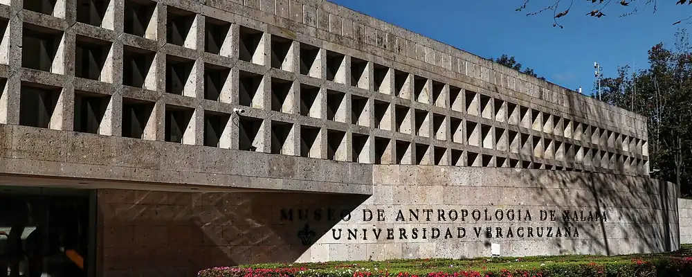
In the 1950s new highways joined Mexico City to Poza Rica and the port of Veracruz to Alvarado and Coatzacoalcos, and the Universidad Veracruzana grew. The Xalapa Museum of Anthropology opened in 1960. The port kept receiving newcomers: more than 4,000 Lebanese during the Porfiriato, over 3,800 Italians between 1858 and 1924, and more than 25,000 Spanish exiles in the mid-20th century. The port of Veracruz was declared four times heroic in 1948.
Veracruz leaned again on what made it, its ports and its passage between the oceans. In 2004 the port of Veracruz, the first fitted out specifically for shipping cars, handled 70% of Mexico's car exports. In the south, a decree of 14 Jun 2019 created the Interoceanic Corridor of the Isthmus of Tehuantepec to modernise the port of Coatzacoalcos and rebuild the old railway to Salina Cruz on the Pacific; passenger service on the line opened on 22 Dec 2023, and 33 Veracruz municipalities lie within the corridor. Five centuries after the fleets of New Spain, the state is still a door between Mexico and the world.
Veracruz, date by date
Before the Spanish before 1519
The colonial centuries 1519 to 1809
- 1519
Cortés founds the Villa Rica de la Vera Cruz and allies with the Totonacs of Cempoala. 3
- 1520
Cortés defeats Pánfilo de Narváez at Cempoala on 27 May. 5
- 1568
Spanish forces trap John Hawkins's fleet at San Juan de Ulúa. 7
- 1575-77
A smallpox epidemic empties Cempoala; survivors move to Xalapa. 5
- 1609-18
Gaspar Yanga's runaways resist Spanish troops and win a free town in 1618. 8
Independence and the Reform 1810 to 1875
The Porfiriato 1876 to 1910
The Revolution 1910 to 1920
Where Veracruz stood: c. 1600, 1910 and today
Interactive maptap or click a state to open its page
c. 1600
Silver, the heartland and the frontier
Veracruz: Ports, sugar and cacao
- Silver mining districts
- Towns, farms and workshops of the old heartland
- Ports, sugar and cacao
- Indigenous south: cochineal, maize, tribute
- Maya lands under encomienda or beyond Spanish rule
- Frontier: missions, presidios, independent peoples
1910
The Porfiriato at its height
Veracruz: Oil
- Mining
- Oil
- Henequén
- Sugar and textile mills
- Haciendas: grain, pulque, cattle
- Export crops: coffee, tobacco, cacao, chicle, timber
- Steel, cotton and the railway north
- Ranching frontier
- The national capital
Today
What each state turns on now
Veracruz: Oil and gas
- Export manufacturing
- Oil and gas
- Tourism
- Farming and agro-exports
- Mining
- Ports and logistics
- Services and government
Why Mexico's own reading of what each state's economy turned on in that period, drawn from the sources listed in each state's room; a classification, not a measurement.
Today's numbers for Veracruz
Output, exports, jobs, wages and investment now, each with its source and date.
The bookBook 6, Where to Go in Mexico, chapter 18
Where to Go in Mexico: The Gulf and the Isthmus, the corridor this state belongs to.
Why MexicoThe national timeline
The turning points of the whole country, each dated, each with its source.
Sources, each with its date
- Wikipedia (English), Veracruz, History section, 3 Nov 2026 · read 3 Nov 2026 · link
- Wikipedia (Spanish), Veracruz de Ignacio de la Llave, history and population sections, 3 Nov 2026 · read 3 Nov 2026 · link
- Wikipedia (Spanish), Veracruz (city), history section, 3 Nov 2026 · read 3 Nov 2026 · link
- Wikipedia (English), El Tajín, 3 Nov 2026 · read 3 Nov 2026 · link
- Wikipedia (English), Zempoala, 3 Nov 2026 · read 3 Nov 2026 · link
- Wikipedia (English), San Lorenzo Tenochtitlán, 3 Nov 2026 · read 3 Nov 2026 · link
- Wikipedia (English), San Juan de Ulúa, 3 Nov 2026 · read 3 Nov 2026 · link
- Wikipedia (English), Yanga, Veracruz, 3 Nov 2026 · read 3 Nov 2026 · link
- Wikipedia (English), Xalapa, 3 Nov 2026 · read 3 Nov 2026 · link
- Wikipedia (English), Cerro Azul, Veracruz, 3 Nov 2026 · read 3 Nov 2026 · link
- Wikipedia (English), Poza Rica, 3 Nov 2026 · read 3 Nov 2026 · link
- INEGI / 1910 census, Table VI, population of the federal entities in 1895, 1900 and 1910 (Universidad Veracruzana transcription), 1910 · read 3 Nov 2026 · link
- INEGI, Censo de Población y Vivienda 2020, results for Veracruz, press release 51/21, 26 Jan 2021 · read 3 Nov 2026 · link
- Data México (Secretaría de Economía), Veracruz profile, Indigenous languages from the 2020 census, 3 Nov 2026 · read 3 Nov 2026 · link
- Wikipedia (English), Mexican oil expropriation, 3 Nov 2026 · read 3 Nov 2026 · link
- Wikipedia (English), Port of Veracruz, 3 Nov 2026 · read 3 Nov 2026 · link
- Wikipedia (English), Interoceanic Corridor of the Isthmus of Tehuantepec, 3 Nov 2026 · read 3 Nov 2026 · link
Pictures
- Anthropology Museum Xalapa: Burkhard Mücke, CC BY-SA 4.0, Wikimedia Commons · read 3 Nov 2026
- El Tajín (Veracruz) 11: Juan Carlos Fonseca Mata, CC BY-SA 4.0, Wikimedia Commons · read 3 Nov 2026

Where the sources disagree
- Villa Rica de la Vera Cruz: Wikipedia (Spanish, city and state) gives 22 Apr 1519; Wikipedia (English, state) gives 18 May 1519. This page says 1519.
- Speakers of Indigenous languages: INEGI gives 663,503 (8.6%); Data México, the source of the per-language counts, gives about 665,000 (8.24%). This page uses INEGI.
- Villa Rica de la Vera Cruz: Wikipedia (Spanish, Veracruz) calls it the first town council on the American mainland; Historia de Tabasco makes a similar claim for Santa María de la Victoria. This page says one of the first.
Tlaxcala
From the murals of Cacaxtla and a republic the Mexica never conquered to the alliance of 1519, colonists for the north, a hard-won statehood and industrial corridors.
All 32 on the mapNext →Yucatán
From Izamal, Uxmal and Chichén Itzá to Spanish Mérida, the Caste War and the henequen fortune, Yucatán is the Maya north that never stopped speaking Maya.