Querétaro
From Sierra Gorda cinnabar miners to the 1810 conspiracy, the fall of an empire and the 1917 Constitution, Querétaro has joined Mexico's centre to its north.
Capital: Querétaro · Became a state: 1823 · Checked 3 Nov 2026
Interactive maptap or click a state to open its page
Querétaro in figures from its history
Frontier of farmers, miners and hunters
Farming villages stood near San Juan del Río and Huimilpan by about 500 BCE, in the age of Teotihuacan, whose influence reached the valleys without ruling them. Around 300 BCE people began building El Cerrito, near today's capital. It grew into a regional political and religious centre with a pyramid about 30 m high, busiest in the Toltec years of 900 to 1200. In the Sierra Gorda a mountain people, the Serranos, lived at Toluquilla and Ranas from as early as 300 BCE until the Spanish conquest. They mined cinnabar, the red mercury ore used to cover the bodies of rulers, traded it far afield and laid out 4 ball courts at Toluquilla alone.
Indigenous languages spoken today
Speakers aged 3 and over, census of 2020 13
People aged 3 and over, 2020 census. In all, 31,383 people in Querétaro speak an Indigenous language, 1.4% of that age group. INEGI publishes only the shares of the 2 largest languages (Otomí 72.2%, Nahuatl 11.1%); the counts shown are those shares applied to the total, rounded to the nearest 10. Pame and Chichimeca Jonaz are also spoken in the Sierra Gorda.
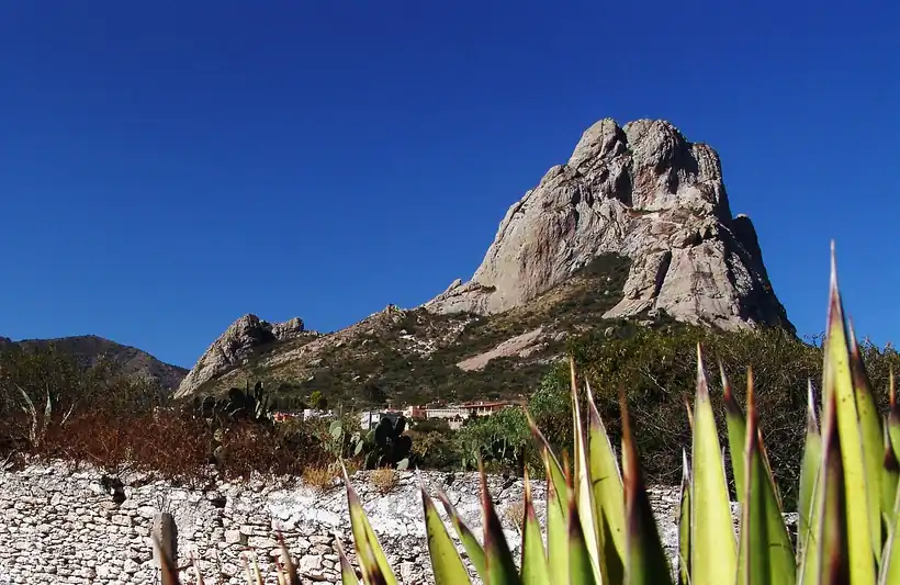

After the 10th century many farmers moved south and the land passed to small villages and hunting peoples. By the 15th century Querétaro was a border. The Aztecs and the Purépecha pressed on the south but never made it tributary, and Pames farmed the northern valleys while Chichimeca Jonaz held the mountains. The Otomí, the first people of the great rock of Bernal, stayed. Otomí is still the main Indigenous language of the state, with about 72% of its 31,383 speakers in 2020, followed by Nahuatl, and Pame survives in the Sierra Gorda.
Gateway to the north, workshops and missions
Spanish settlement came between 1529 and 1531, led jointly by Hernán Pérez de Bocanegra and the Otomí lord Conín of Jilotepec, baptised Fernando de Tapia. Tradition dates the founding of Querétaro to 25 Jul 1531, after a clash on Sangremal hill where, the chronicles say, an eclipse struck fear and the apostle James appeared; hence the name Santiago de Querétaro. Otomí leaders shared local power with the Spanish well into the 17th century. The town became a city in 1655 and prospered as the junction that tied the north and west to the centre of New Spain.
Interactive maptap or click a state to open its page
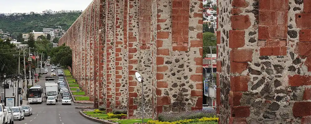
In the 18th century Querétaro became the first major producer of woollen cloth in New Spain, woven in workshops called obrajes, and late in the century the royal tobacco factory there was the second most important in the colony. Silver came from El Doctor. Between 1726 and 1738 Juan Antonio de Urrutia y Arana built the 74-arch aqueduct that watered the city until 1970. The Sierra Gorda stayed outside Spanish control until José de Escandón broke Chichimeca resistance at Media Luna in 1748. Junípero Serra and other Franciscans then directed the building of 5 missions, Jalpan the first in 1751-58, raised by Pame hands.
Places in its history
Querétaro
City · 1531
State capital, founded in 1531; seat of the 1810 conspiracy and the 1917 Constitution. 3
El Cerrito
Archaeological site · c. 300 BCE-1500 CE
Ceremonial centre with a pyramid about 30 m high, busiest in Toltec times. 5
San Juan del Río
City · 1531
Founded in 1531 as an Indigenous town; a toll and bridge stop on the Camino Real de Tierra Adentro. 8
Peña de Bernal
Archaeological site · Pre-Hispanic
A monolith 433 m tall, first settled by the Otomí and held sacred by the Chichimecas. 9
Landa mission
Mission · 1761-68
Santa María del Agua de Landa, the last of the 5 Sierra Gorda missions to be built. 10
Jalpan mission
Mission · 1751-58
First of the 5 Franciscan missions of the Sierra Gorda, World Heritage since 2003. 4
The conspiracy, the empire's end and the Constitution
The plot that became the War of Independence was hatched in Querétaro by Miguel Hidalgo, Ignacio Allende, the corregidor, or royal district magistrate, Miguel Domínguez and his wife, Josefa Ortiz de Domínguez. When Epigmenio González was caught with a store of weapons, Josefa sent word to Hidalgo at Dolores, and the rising was moved up to mid-Sep 1810. González spent the years 1810 to 1838 in prison in the Philippines. The city itself stayed royalist, loyal to the Spanish Crown, and was one of the last strongholds to fall. Querétaro became a state on 23 Dec 1823, then had 25 governors between 1824 and 1855 as liberals and conservatives fought over federalism and the place of the Church.
1810 to 1920 in Querétaro
From the timeline below, coloured by era
- 1810The Querétaro conspiracy is discovered and the rising for Independence is brought forward. 1
- 1823Querétaro becomes a state of the federation on 23 Dec. 1
- 1848The Treaty of Guadalupe Hidalgo, ending the war with the USA, is ratified in Querétaro. 2
- 1867Maximilian is shot on the Cerro de las Campanas on 19 Jun. 2
- 1882The railway reaches the capital. 1
- 1909Workers at El Hércules, the country's largest textile mill, hold the state's biggest strike. 1
- 1917The Constitution of Mexico is proclaimed in Querétaro on 5 Feb. 2
During the war with the USA the national government moved here, and the Treaty of Guadalupe Hidalgo was ratified in the city in 1848. Maximilian, the Austrian archduke the French had placed on a Mexican throne, made his last stand in Querétaro; he was captured and shot on the Cerro de las Campanas on 19 Jun 1867. Under Porfirio Díaz, who ruled from 1876 to 1911 (the Porfiriato), the railway arrived in 1882 and El Hércules grew into the country's largest textile mill, the scene in 1909 of the state's biggest strike. Revolts broke out in Jalpan and Cadereyta during the Revolution. Venustiano Carranza, leader of the victorious Constitutionalist faction, moved the national government to Querétaro in 1916, and on 5 Feb 1917 the new Constitution was proclaimed in the Teatro Iturbide, later renamed Teatro de la República.
From mill town to industrial corridor
After the Revolution the economy recovered slowly. Growth picked up between 1940 and 1960, when industry modernised and the population rose fast. Industrial parks went up north of the capital, and over the next 30 years the city grew to more than 4 times its earlier size. The state's population growth peaked at more than 4% a year in the 1970s. The old aqueduct, which had served since the 1730s, carried its last water to the city in 1970.
The region, c. 1600 and today
What each state turned on, by the era table below; Querétaro outlined in gold.
Interactive maptap or click a state to open its page
c. 1600
Querétaro: Towns, farms and workshops of the old heartland
- Silver mining districts
- Towns, farms and workshops of the old heartland
Today
Querétaro: Export manufacturing
- Export manufacturing
- Farming and agro-exports
- Services and government
The countryside changed more slowly. Otomí communities in Amealco and the semi-desert centre, and Pame villages in the Sierra Gorda, kept their languages, while the 5 missions of the Sierra were restored between 1979 and 2002. In 1996 the historic centre of the capital was declared a World Heritage Site, and the city took back its full name, Santiago de Querétaro. From the mid-1990s the state saw an industrial boom, and in 1997 it elected its first governor from outside the party that had ruled since the Revolution.
Querétaro built on its oldest asset, its place on the road between Mexico City and the north. A plant of the Canadian firm Bombardier opened in 2005 and anchored an aerospace industry that has made the capital what is often called the most advanced centre of aeronautics in Mexico. Industrial parks kept spreading north of the city, and families from the northern border states moved in. Water, the old limit on growth, called for a second aqueduct, Acueducto II, which opened in 2011, almost three centuries after Urrutia's arches. The junction that once moved silver, wool and soldiers now moves aircraft parts.
Querétaro, date by date
Before the Spanish before 1519
The colonial centuries 1519 to 1809
- 1531
Querétaro is founded, by tradition on 25 Jul, by Spaniards and the Otomí lord Conín. 2
- 1655
The viceroy grants Querétaro the title of city. 2
- 1726-38
The 74-arch aqueduct is built to bring water to the city. 3
- 1748
José de Escandón defeats the Chichimecas at Media Luna, opening the Sierra Gorda. 1
- 1751-58
The mission church of Jalpan, the first of 5 in the Sierra Gorda, is built. 4
Independence and the Reform 1810 to 1875
- 1810
The Querétaro conspiracy is discovered and the rising for Independence is brought forward. 1
- 1823
Querétaro becomes a state of the federation on 23 Dec. 1
- 1848
The Treaty of Guadalupe Hidalgo, ending the war with the USA, is ratified in Querétaro. 2
- 1867
Maximilian is shot on the Cerro de las Campanas on 19 Jun. 2
The Porfiriato 1876 to 1910
The Revolution 1910 to 1920
- 1917
The Constitution of Mexico is proclaimed in Querétaro on 5 Feb. 2
Where Querétaro stood: c. 1600, 1910 and today
Interactive maptap or click a state to open its page
c. 1600
Silver, the heartland and the frontier
Querétaro: Towns, farms and workshops of the old heartland
- Silver mining districts
- Towns, farms and workshops of the old heartland
- Ports, sugar and cacao
- Indigenous south: cochineal, maize, tribute
- Maya lands under encomienda or beyond Spanish rule
- Frontier: missions, presidios, independent peoples
1910
The Porfiriato at its height
Querétaro: Haciendas: grain, pulque, cattle
- Mining
- Oil
- Henequén
- Sugar and textile mills
- Haciendas: grain, pulque, cattle
- Export crops: coffee, tobacco, cacao, chicle, timber
- Steel, cotton and the railway north
- Ranching frontier
- The national capital
Today
What each state turns on now
Querétaro: Export manufacturing
- Export manufacturing
- Oil and gas
- Tourism
- Farming and agro-exports
- Mining
- Ports and logistics
- Services and government
Why Mexico's own reading of what each state's economy turned on in that period, drawn from the sources listed in each state's room; a classification, not a measurement.
Today's numbers for Querétaro
Output, exports, jobs, wages and investment now, each with its source and date.
The bookBook 6, Where to Go in Mexico, chapter 15
Where to Go in Mexico: The Bajío and Center-North, the corridor this state belongs to.
Why MexicoThe national timeline
The turning points of the whole country, each dated, each with its source.
Sources, each with its date
- Wikipedia (English), Querétaro, History and Demographics sections, 3 Nov 2026 · read 3 Nov 2026 · link
- Wikipedia (Spanish), Querétaro, 3 Nov 2026 · read 3 Nov 2026 · link
- Wikipedia (English), Querétaro (city), 3 Nov 2026 · read 3 Nov 2026 · link
- Wikipedia (English), Franciscan Missions in the Sierra Gorda of Querétaro, 3 Nov 2026 · read 3 Nov 2026 · link
- Wikipedia (English), El Cerrito (archaeological site), 3 Nov 2026 · read 3 Nov 2026 · link
- INAH, visitor guide to the Toluquilla archaeological zone (English edition), 2019 · read 3 Nov 2026 · link
- Tercer Censo de Población de los Estados Unidos Mexicanos, 1910, Table VI, population of the federal entities in 1895, 1900 and 1910 (Universidad Veracruzana digital edition), 1910 · read 3 Nov 2026 · link
- Wikipedia (Spanish), San Juan del Río (Querétaro), 3 Nov 2026 · read 3 Nov 2026 · link
- Wikipedia (English), Peña de Bernal, 3 Nov 2026 · read 3 Nov 2026 · link
- Wikipedia (English), Landa de Matamoros, 3 Nov 2026 · read 3 Nov 2026 · link
- INAH, Lugares INAH, Toluquilla archaeological zone, 3 Nov 2026 · read 3 Nov 2026 · link
- INEGI, Censo de Población y Vivienda 2020, results for Querétaro, press release 42/21, 26 Jan 2021 · read 3 Nov 2026 · link
- INEGI, Panorama sociodemográfico de Querétaro, Censo de Población y Vivienda 2020, 2021 · read 3 Nov 2026 · link
Pictures
- Acueducto 20170917p2: Carlos Valenzuela, CC BY-SA 4.0, Wikimedia Commons · read 3 Nov 2026
- La Peña de Bernal: Arq. Carlos G. Calzada, CC BY-SA 4.0, Wikimedia Commons · read 3 Nov 2026

Where the sources disagree
- Population in 1900: the 1910 census table and Wikipedia (English) give 232,389; Wikipedia (Spanish) gives 232,305. This page uses the census figure, 232,389.
- Treaty of Guadalupe Hidalgo: Wikipedia (English) says it was signed in Querétaro; Wikipedia (Spanish) says it was ratified there. The treaty was signed at Guadalupe Hidalgo and ratified in Querétaro; this page says ratified.
- Toluquilla: INAH's visitor guide (2019) gives 300 BCE to 1550 CE; INAH's site page says inhabited from about 400 CE. This page says as early as 300 BCE.
Puebla
From early maize at Tehuacán and the pyramid of Cholula to the City of the Angels, the battle of 5 May 1862, textile mills and Volkswagen.
All 32 on the mapNext →Quintana Roo
Quintana Roo went from Maya Cobá and Tulum to the rebel shrine of the Talking Cross, a chicle frontier on the Belize border, and finally Cancún, built on a near-empty island after 1970.