Campeche
Campeche runs from Calakmul's Snake Kingdom to a walled port that shipped logwood and fought off pirates, then to chicle camps in the forest and the oil of Cantarell.
Capital: Campeche · Became a state: 1863 · Checked 3 Nov 2026
Interactive maptap or click a state to open its page
Campeche in figures from its history
Edzná, Becán and the Snake Kingdom
The earliest signs of people in what is now Campeche date to around 550 BCE. Over the next 1,500 years the Maya filled the land with cities in several styles. Edzná, inland from the coast, was inhabited by 400 BCE and had grown into a major city by 200 CE. Becán, in the Río Bec country, was ringed in about 250 CE by a ditch and ramparts enclosing 25 hectares. Off the coast, the small island of Jaina became an elite burial ground with an estimated 20,000 graves, famous for its clay figurines.
Indigenous languages spoken today
Speakers aged 3 and over, census of 2020 5
In all, 91,801 people aged 3 and over spoke an Indigenous language in 2020, 10.4% of that age group. Mam and Tsotsil are also spoken.
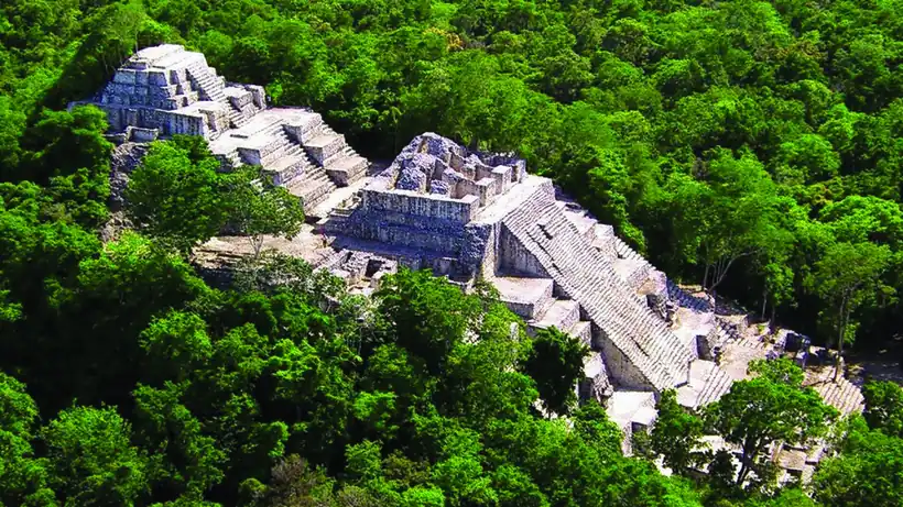

In the southern forest rose Calakmul, seat of the Kaan, the Snake Kingdom, which dominated much of the Classic Maya world through alliances and war and drew Edzná into its orbit. At its height it held some 50,000 people in a city of over 70 km², and Structure 2 rises more than 45 m. Its long war with Tikal ended in defeat in 695. After about 1000 CE the great cities emptied and smaller Maya and Chontal domains took their place, among them Chakán Putum, today's Champotón. Maya is still spoken by 70,603 people in the state, alongside Ch'ol, Tseltal and Q'anjob'al.
Logwood, shipyards and the walled port
Francisco Hernández de Córdoba landed at Can Pech in 1517, then lost a battle at Chakán Putum, which the Spanish called the Port of the Bad Fight. He died of his wounds some days later. Francisco de Montejo founded a first Salamanca de Campeche in 1531, and his son founded San Francisco de Campeche on 4 Oct 1540. Franciscans and sugar cane reached Champotón in 1546. The port became a trade hub of the Spanish Caribbean, compared with Havana and Cartagena. It shipped farm goods, tropical hardwoods and logwood, the palo de Campeche used to dye cloth, and its shipyards were well known.
Interactive maptap or click a state to open its page
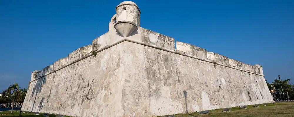
Wealth drew pirates. William Parker sacked the town in 1597, and more raids followed in 1633 and 1663. In 1685 Laurens de Graaf took Campeche and about twenty nearby towns and held them for weeks. Between 1686 and 1704 the town was closed in by a hexagonal wall 2,560 m long with eight bastions. Down the coast, English logwood cutters held the Isla de Tris for generations until Alonso Felipe de Andrade drove them out in Jul 1717 and died in the fighting, and the town took the name of the Virgin of Carmen. Charles III made Campeche a city on 1 Oct 1777.
Breaking from Mérida, dyewood and haciendas
Campeche backed the Plan of Iguala, the 1821 agreement that sealed independence, in Sep 1821, but independence was hard on the port. Sisal, opened in 1811, had already pulled trade toward Mérida, and the end of slavery cut farm output. A proposal to split the peninsula into two states was turned down in 1824. After the Caste War began in 1847 and new revolts followed the Constitution of 1857, an 1858 agreement divided the peninsula. Benito Juárez recognised the new state on 19 Feb 1862, and the final decree came on 29 Apr 1863, with Pablo García as first governor. During the French Intervention of 1862-67, which set Maximilian on a Mexican throne, republicans won at Hecelchakán in 1864 and retook the city in 1867.
1810 to 1920 in Campeche
From the timeline below, coloured by era
Under the Porfiriato, Porfirio Díaz's rule of 1876-1911, the state lived on dyewood, timber and haciendas. Logwood exports peaked in 1896 and had fallen sharply by 1915. Between 1900 and 1910 fourteen landowners held 147 haciendas, about a fifth of the state, and in 1910 seven North American timber companies were registered in Carmen. The first concession in the chicle zones, where workers tapped the sapodilla tree for the gum used in chewing gum, was granted in 1886. The Revolution came without great battles. In 1914 Governor Joaquín Mucel issued decree No. 6, which ended debt peonage, the disguised slavery that bound workers to the haciendas through debts they could never repay, and a new state constitution followed in 1917.
From chicle and shrimp to the oil of Cantarell
The forest economy peaked and then emptied the land. Large volumes of chicle passed through the customs houses of Campeche and Carmen from 1930 to 1942, and in 1939-43 it supplied about 60% of the state budget, but the market fell away after the Second World War. Of the settlements counted in 1920, 231 had vanished by the 1940 census, after timber and chicle extraction peaked. From 1946 shrimp companies settled in Ciudad del Carmen, and shrimp shaped its economy for some 35 years.
The region, c. 1600 and today
What each state turned on, by the era table below; Campeche outlined in gold.
Interactive maptap or click a state to open its page
c. 1600
Campeche: Maya lands under encomienda or beyond Spanish rule
- Ports, sugar and cacao
- Indigenous south: cochineal, maize, tribute
- Maya lands under encomienda or beyond Spanish rule
Today
Campeche: Oil and gas
- Oil and gas
- Tourism
- Farming and agro-exports
- Services and government
Then came oil, found offshore. A fisherman, Rudesindo Cantarell, reported an oil slick in the Sound of Campeche; technicians came to investigate in Mar 1971, the field was confirmed in 1976, and the first Cantarell barrels flowed in 1979. The state grew from 251,556 people in 1970 to 420,553 in 1980, and Ciudad del Carmen became the base of the offshore industry. Oil money restored more than a thousand facades in the old city. In the 1980s about 25,000 Guatemalan refugees found shelter in the state and Mennonite farmers settled around Hopelchén and Hecelchakán. Textile maquiladoras, assembly plants producing for export, opened in the 1990s, and the walled city became a World Heritage Site in 1999.
Then the oil that had carried the state began to run down. Pemex started injecting nitrogen into Cantarell in 2000 to hold up its pressure, the field reached its peak in 2004, and from 2005 its output fell year after year. Calakmul became a World Heritage Site in 2002, and the Tren Maya, opened on 15 Dec 2023, now stops at Campeche, Edzná, Escárcega and Xpujil, near Calakmul, with the stated aim of drawing visitors inland. From logwood to chicle to Cantarell, Campeche has lived on what its forests and its sea sold to outside markets, and each boom has ended; the Maya cities and the forest are now part of what it offers.
Campeche, date by date
Before the Spanish before 1519
- c. 550 BCE
The earliest known signs of human settlement in today's Campeche. 2
- c. 200
Edzná has grown into a major city. 10
- c. 250
Becán is ringed by a defensive ditch and ramparts. 11
- 695
Tikal defeats Calakmul, ending the Snake Kingdom's height. 8
- 1517
Hernández de Córdoba lands at Can Pech and is beaten at Champotón. 13
The colonial centuries 1519 to 1809
- 1540
Montejo the Younger founds San Francisco de Campeche on 4 Oct. 6
- 1685
Laurens de Graaf takes and sacks Campeche. 7
- 1686-1704
The 2,560 m wall with eight bastions is built. 6
- 1717
English logwood cutters are driven from the Isla de Tris, now Carmen. 14
- 1777
Charles III grants Campeche the title of city on 1 Oct. 6
Independence and the Reform 1810 to 1875
- 1863
Campeche becomes a state by decree of 29 Apr. 2
The Porfiriato 1876 to 1910
- 1896
Logwood exports reach their peak. 2
The Revolution 1910 to 1920
- 1914
Decree No. 6 abolishes disguised slavery on the haciendas. 2
Modern Mexico after 1920
- 1939-43
Chicle supplies about 60% of the state budget. 2
- 1971
Rudesindo Cantarell's oil slick is investigated off Ciudad del Carmen. 14
- 1979
The first barrels flow from the Cantarell field. 2
- 1999
The walled city of Campeche becomes a World Heritage Site. 7
- 2004
The Cantarell field reaches its peak; its output falls from 2005. 15
- 2023
The Tren Maya opens on 15 Dec, with stops at Campeche, Edzná, Escárcega and Xpujil. 16
Where Campeche stood: c. 1600, 1910 and today
Interactive maptap or click a state to open its page
c. 1600
Silver, the heartland and the frontier
Campeche: Maya lands under encomienda or beyond Spanish rule
- Silver mining districts
- Towns, farms and workshops of the old heartland
- Ports, sugar and cacao
- Indigenous south: cochineal, maize, tribute
- Maya lands under encomienda or beyond Spanish rule
- Frontier: missions, presidios, independent peoples
1910
The Porfiriato at its height
Campeche: Henequén
- Mining
- Oil
- Henequén
- Sugar and textile mills
- Haciendas: grain, pulque, cattle
- Export crops: coffee, tobacco, cacao, chicle, timber
- Steel, cotton and the railway north
- Ranching frontier
- The national capital
Today
What each state turns on now
Campeche: Oil and gas
- Export manufacturing
- Oil and gas
- Tourism
- Farming and agro-exports
- Mining
- Ports and logistics
- Services and government
Why Mexico's own reading of what each state's economy turned on in that period, drawn from the sources listed in each state's room; a classification, not a measurement.
Today's numbers for Campeche
Output, exports, jobs, wages and investment now, each with its source and date.
The bookBook 6, Where to Go in Mexico, chapter 19
Where to Go in Mexico: The Peninsula, the corridor this state belongs to.
Why MexicoThe national timeline
The turning points of the whole country, each dated, each with its source.
Sources, each with its date
- Wikipedia (English), Campeche, History section, 3 Nov 2026 · read 3 Nov 2026 · link
- Wikipedia (Spanish), Campeche, history section, 3 Nov 2026 · read 3 Nov 2026 · link
- Tercer Censo de Población 1910, Table VI, population by federal entity in 1895, 1900 and 1910 (digital copy, Universidad Veracruzana), 1910 · read 3 Nov 2026 · link
- INEGI, Censo de Población y Vivienda 2020, results for Campeche (press bulletin), Jan 2021 · read 3 Nov 2026 · link
- Por Esto!, "Disminuye 2% los hablantes de lengua indígena en Campeche: INEGI", speaker counts by language, 28 Nov 2021 · read 3 Nov 2026 · link
- Wikipedia (Spanish), San Francisco de Campeche, 3 Nov 2026 · read 3 Nov 2026 · link
- Wikipedia (English), Campeche, Campeche (city), 3 Nov 2026 · read 3 Nov 2026 · link
- Wikipedia (English), Calakmul, 3 Nov 2026 · read 3 Nov 2026 · link
- INAH, Lugares INAH, Ancient Maya City and Protected Tropical Forests of Calakmul, Campeche (World Heritage), 3 Nov 2026 · read 3 Nov 2026 · link
- Wikipedia (English), Edzna, 3 Nov 2026 · read 3 Nov 2026 · link
- Wikipedia (English and Spanish), Becan / Becán, 3 Nov 2026 · read 3 Nov 2026 · link
- Wikipedia (English), Jaina Island, 3 Nov 2026 · read 3 Nov 2026 · link
- Wikipedia (English), Champotón, Campeche, 3 Nov 2026 · read 3 Nov 2026 · link
- Wikipedia (English), Ciudad del Carmen, 3 Nov 2026 · read 3 Nov 2026 · link
- Wikipedia (English), Cantarell Field, 3 Nov 2026 · read 3 Nov 2026 · link
- Wikipedia (English), Tren Maya, 3 Nov 2026 · read 3 Nov 2026 · link
Pictures
- San Francisco de Campeche, Campeche Mexico, dic 2023 - 5: xiquinhosilva, CC BY 2.0, Wikimedia Commons · read 3 Nov 2026
- Calakmul Maya pyramid: Lugares INAH, CC BY-SA 4.0, Wikimedia Commons · read 3 Nov 2026

Where the sources disagree
- City title: Wikipedia (Spanish, San Francisco de Campeche and Campeche) gives 1 Oct 1777 (Charles III); Wikipedia (English, Campeche) gives 1774. This page uses 1777.
- World Heritage listing of the walled city: Wikipedia (English, city) and Wikipedia (Spanish) give 1999; Wikipedia (English, state) gives 1997. This page uses 1999.
- Laurens de Graaf's sack of 1685: Wikipedia (English) says over thirty days and about a third of the population killed; Wikipedia (Spanish) says two months. This page says for weeks, with no death toll.
- Cantarell (both articles read 5 Nov 2026): Wikipedia (English, Cantarell Field) dates Rudesindo Cantarell's sighting to 1972 and the discovery to 1976; Wikipedia (Spanish, Complejo Cantarell) has Pemex exploring the slick in Mar 1971, ten years after he found it. Both give 1979 for the first production. This page leaves his report undated and gives Mar 1971 for the investigation.
- First Cantarell well (read 5 Nov 2026): Wikipedia (English, Cantarell Field) dates the discovery to 1976 and first production to 1979; Wikipedia (Spanish, Complejo Cantarell) puts the first producing well, Chac, eight years after 1971. Neither gives a month. This page gives 1976 and 1979.
- Becán: Wikipedia (English) says occupied by about 550 BCE and probably abandoned by about 1200; Wikipedia (Spanish) says from about 600 BCE and fully abandoned about 1450. This page uses the English dates.
- Speakers by language: Por Esto! (2021), reporting INEGI census data, totals INEGI's 91,801; DataMexico gives other 2020 figures. This page uses Por Esto!.
Baja California Sur
Painted caves of the Cochimí, pearls and Jesuit missions, a French copper town, and a remote territory that became a state and a tourist coast in 1974.
All 32 on the mapNext →Coahuila
Desert hunters and lake peoples, Tlaxcalan settlers at Saltillo, a frontier that once included Texas, then cotton ejidos, coal and the steel of Monclova.