Morelos
From Chalcatzingo and Xochicalco to Cortés's sugar estates, the siege of Cuautla and Zapata's fight for land, the valleys of Morelos turned on who held the soil.
Capital: Cuernavaca · Became a state: 1869 · Checked 3 Nov 2026
Interactive maptap or click a state to open its page
Morelos in figures from its history
Chalcatzingo, Xochicalco and the Tlahuica valleys
Hunters and gatherers lived near Yautepec and Chimalacatlán as early as 6000 BCE. At Chalcatzingo, in today's municipality of Jantetelco, settlement may have begun by 1500 BCE, and from about 900 BCE its people carved Olmec-style reliefs into the hillside. The best known, El Rey, shows a figure seated in a cave beneath rain clouds. The town peaked between 700 and 500 BCE with 500 to 1,000 people.
Indigenous languages spoken today
Speakers aged 3 and over, census of 2020 15
In all, 38,110 people aged 3 and over spoke an Indigenous language in 2020, 2.0% of that age group, up from 31,905 in 2010. Counts by language come from Data México, built on the same census. Mixtec and Tlapanec speakers are mostly families who came from Guerrero and Oaxaca.
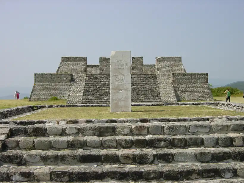

Xochicalco was founded around 650 CE on a hilltop and became a city of up to 20,000 people between 700 and 900. Its Temple of the Feathered Serpent blends Teotihuacan and Maya styles. The city was burned around 900 and was listed by UNESCO in 1999. From the 12th century Nahua groups arrived. Xochimilcas settled Tepoztlán, Tetela and Hueyapan, and Tlahuicas settled Cuauhnáhuac, today Cuernavaca, by about 1250. The Tlahuicas ruled some 50 city-states and were known for cotton cloth, astronomy and irrigated fields. The Mexica took Cuauhnáhuac under Itzcóatl in the 1420s and 1430s and in 1487 split the region into two tribute provinces that paid mostly in cotton goods. Nahuatl is still the main Indigenous language of the state.
Cortés's marquisate and the sugar valleys
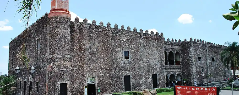
After the Spanish retreat of 1520, expeditions entered the valleys. Gonzalo de Sandoval attacked Huaxtepec, and Cortés took Tlayacapan and Yautepec and reached Cuauhnáhuac on 13 Apr 1521, burning and sacking it. Cortés built a palace there, finished in 1535, and in 1529 was named Marquis of the Valley of Oaxaca, a title that gave him personally the land and tribute of the towns in his grant. In Morelos he held about 4,000 km², with some 80 communities, 8 haciendas and 2 sugar plantations, and his heirs kept the estate until it was confiscated in 1809.
Interactive maptap or click a state to open its page
The friars came quickly. Franciscans reached Cuernavaca in 1529, and about 500 religious buildings went up in 50 years. The Dominican convent of Tepoztlán, built by the town's people between 1555 and 1580, is World Heritage today, as is the cathedral and convent complex of Cuernavaca. House-by-house censuses written in Nahuatl in the 1530s are among the oldest local records. Sugar cane displaced maize and cotton on the best irrigated land. In 1619 the Cortés heirs granted 200 hectares on the Tetelpa River, with a sugar mill, at Zacatepec. The estates made fortunes for owners who lived elsewhere and left debt and poverty among the people who cut the cane.
Places in its history
Cuernavaca
City · c. 1250; city 1834
State capital; Tlahuica Cuauhnáhuac, then seat of Cortés's marquisate. 5
Xochicalco
Archaeological site · c. 650-900
Hilltop city with the Temple of the Feathered Serpent; UNESCO 1999. 3
Anenecuilco
City · Birthplace of Emiliano Zapata, 1879
Village whose land fight with the hacienda of El Hospital fed the Revolution. 8
Zacatepec
Hacienda · 1619; mill 1938
Colonial sugar estate; Cárdenas opened its ejido sugar mill in 1938. 11
The siege of Cuautla and Zapata's fight for land
Conditions on the sugar estates made the call to arms of 1810 popular. In 1812 José María Morelos held Cuautla against Félix María Calleja from 19 Feb to 2 May, a siege of 72 days that both sides claimed as a victory; it later gave the state its name. After Independence the region was the district of Cuernavaca in the State of Mexico. In the Reform War of 1858-61, the civil war between liberals and conservatives over the Reform laws that sold off Church and communal lands, Cuautla was liberal and Cuernavaca conservative, and Emperor Maximilian later used Cuernavaca as a summer residence. Morelos became a state on 17 Apr 1869, with Francisco Leyva as its first governor.
1810 to 1920 in Morelos
From the timeline below, coloured by era
During the Porfiriato, Porfirio Díaz's rule of 1876-1911, the estates installed steam mills and centrifuges and grew at the villages' expense; between 1884 and 1905, 18 towns disappeared. At Anenecuilco the hacienda of El Hospital cut the village off from its pastures and water. Emiliano Zapata, born there, rose against Díaz, won at Cuautla in May 1911 and on 28 Nov 1911 proclaimed the Plan de Ayala, which demanded the return of village lands. The Carrancistas, Venustiano Carranza's Constitutionalist armies, retook much of the state, and Cuernavaca fell to about 30,000 troops on 2 May 1916. Zapata was ambushed and killed at the hacienda of Chinameca on 10 Apr 1919. Land reform under Obregón later followed the plan, and some of Zapata's former followers joined the Cristero rising of 1926, the Catholic revolt against the government's anti-clerical laws.
Ejido cane, the Cuernavaca road and new factories
On 5 Feb 1938 President Lázaro Cárdenas opened the sugar mill at Zacatepec, built in the shell of an old hacienda to improve the lives of mill workers and ejidatarios, holders of ejido land, the farmland granted to communities under the land reform. Its cooperative members founded the Zacatepec football club in 1948. Unrest did not end. Rubén Jaramillo led farmers' revolts in 1943-44 and again from 1953 to 1958, and he was killed by federal police at Xochicalco on 23 May 1962.
The region, c. 1600 and today
What each state turned on, by the era table below; Morelos outlined in gold.
Interactive maptap or click a state to open its page
c. 1600
Morelos: Ports, sugar and cacao
- Towns, farms and workshops of the old heartland
- Ports, sugar and cacao
Today
Morelos: Export manufacturing
- Export manufacturing
- Oil and gas
- Tourism
- Services and government
Its places in the modern era
Numbered as on the map above
- 4Anenecuilco · Birthplace of Emiliano Zapata, 1879
Village whose land fight with the hacienda of El Hospital fed the Revolution. 8
Roads tied the state to the capital. The Mexico City-Cuernavaca toll highway and the road to Acapulco opened in 1952, and the old rail line from Mexico City through Cuernavaca to Iguala closed in 1963. The CIVAC industrial park opened in Jiutepec in 1966 on about 4,000 hectares of communal land, with little paid to its owners, and on 12 May 1966 Nissan Mexicana, incorporated in 1961, opened its plant there, Nissan's first factory outside Japan. The IMSS water park at Oaxtepec opened the same year. Cuernavaca grew from 85,620 people in 1960 to 368,166 in 1980 as a retreat from Mexico City, and more so after the 1985 earthquake. Farm workers from Guerrero, Oaxaca and Puebla came to cut cane and pick tomatoes and onions, which is why Mixtec and Tlapanec are now spoken alongside Nahuatl.
Cuernavaca stayed a retreat from Mexico City, and the CIVAC factories and the ejido cane of Zacatepec grew side by side until Nissan closed its CIVAC plant on 27 Mar 2026. On 19 Sep 2017, 32 years to the day after the 1985 earthquake, a magnitude 7.1 quake struck at 13:14 with its epicentre 12 km south-east of Axochiapan, in the east of Morelos. In Jojutla alone 652 homes were destroyed and 1,157 damaged. The question that has run through Morelos since Cortés planted cane, who holds the land of these valleys, is still answered between ejido fields and the growth that the capital sends south.
Morelos, date by date
Before the Spanish before 1519
- c. 6000 BCE
Hunters and gatherers live near Yautepec and Chimalacatlán. 1
- c. 700-500 BCE
Chalcatzingo, with its Olmec-style rock reliefs, reaches its peak. 4
- c. 650
Xochicalco is founded on a hilltop; it flourishes until it is burned around 900. 3
- c. 1250
The Tlahuicas settle Cuauhnáhuac, today Cuernavaca. 1
- 1487
The Mexica divide the region into two tribute provinces, Cuauhnáhuac and Huaxtepec. 1
The colonial centuries 1519 to 1809
Independence and the Reform 1810 to 1875
The Porfiriato 1876 to 1910
- 1884-1905
Sugar estates expand and 18 towns disappear. 1
The Revolution 1910 to 1920
Modern Mexico after 1920
- 1938
Cárdenas opens the Zacatepec sugar mill on 5 Feb. 11
- 1952
The Mexico City-Cuernavaca toll highway opens. 1
- 1962
Farm leader Rubén Jaramillo is killed at Xochicalco on 23 May. 1
- 1966
The CIVAC industrial park opens in Jiutepec. 1
- 2017
A magnitude 7.1 earthquake centred near Axochiapan strikes on 19 Sep 2017; Jojutla is among the hardest-hit towns. 16
Where Morelos stood: c. 1600, 1910 and today
Interactive maptap or click a state to open its page
c. 1600
Silver, the heartland and the frontier
Morelos: Ports, sugar and cacao
- Silver mining districts
- Towns, farms and workshops of the old heartland
- Ports, sugar and cacao
- Indigenous south: cochineal, maize, tribute
- Maya lands under encomienda or beyond Spanish rule
- Frontier: missions, presidios, independent peoples
1910
The Porfiriato at its height
Morelos: Sugar and textile mills
- Mining
- Oil
- Henequén
- Sugar and textile mills
- Haciendas: grain, pulque, cattle
- Export crops: coffee, tobacco, cacao, chicle, timber
- Steel, cotton and the railway north
- Ranching frontier
- The national capital
Today
What each state turns on now
Morelos: Export manufacturing
- Export manufacturing
- Oil and gas
- Tourism
- Farming and agro-exports
- Mining
- Ports and logistics
- Services and government
Why Mexico's own reading of what each state's economy turned on in that period, drawn from the sources listed in each state's room; a classification, not a measurement.
Today's numbers for Morelos
Output, exports, jobs, wages and investment now, each with its source and date.
The bookBook 6, Where to Go in Mexico, chapter 16
Where to Go in Mexico: The Center, the corridor this state belongs to.
Why MexicoThe national timeline
The turning points of the whole country, each dated, each with its source.
Sources, each with its date
- Wikipedia (English), Morelos, History and Indigenous languages sections, 3 Nov 2026 · read 3 Nov 2026 · link
- Wikipedia (Spanish), Morelos, history section, 3 Nov 2026 · read 3 Nov 2026 · link
- Wikipedia (English), Xochicalco, 3 Nov 2026 · read 3 Nov 2026 · link
- Wikipedia (English), Chalcatzingo, 3 Nov 2026 · read 3 Nov 2026 · link
- Wikipedia (English), Cuernavaca, 3 Nov 2026 · read 3 Nov 2026 · link
- Wikipedia (English), Siege of Cuautla, 3 Nov 2026 · read 3 Nov 2026 · link
- Wikipedia (English), Plan of Ayala, 3 Nov 2026 · read 3 Nov 2026 · link
- Wikipedia (English), Anenecuilco, 3 Nov 2026 · read 3 Nov 2026 · link
- Wikipedia (Spanish), Chinameca (Morelos), 3 Nov 2026 · read 3 Nov 2026 · link
- Wikipedia (English), Tepoztlán, 3 Nov 2026 · read 3 Nov 2026 · link
- Wikipedia (English), Zacatepec, Morelos, 3 Nov 2026 · read 3 Nov 2026 · link
- Wikipedia (English), Club Zacatepec, 3 Nov 2026 · read 3 Nov 2026 · link
- INEGI / 1910 census, Table VI, population of the federal entities in 1895, 1900 and 1910 (Universidad Veracruzana transcription), 1910 · read 3 Nov 2026 · link
- INEGI, Censo de Población y Vivienda 2020, results for Morelos, press release 52/21, 26 Jan 2021 · read 3 Nov 2026 · link
- Data México (Secretaría de Economía), Morelos profile, Indigenous languages from the 2020 census, 3 Nov 2026 · read 3 Nov 2026 · link
- Wikipedia (English), 2017 Puebla earthquake, 3 Nov 2026 · read 3 Nov 2026 · link
- Expansión, "Nissan cierra histórica planta CIVAC en Morelos tras 60 años", 27 Mar 2026, 27 Mar 2026 · read 3 Nov 2026 · link
Pictures
- Cuernavaca Palacio Cortes: Zoran Lazic, CC BY-SA 3.0, Wikimedia Commons · read 3 Nov 2026
- Mexico xochicalco pyramids: Maxtreiber, Public domain, Wikimedia Commons · read 3 Nov 2026

Where the sources disagree
- Statehood: Wikipedia (English) gives admission on 17 Apr 1869; Wikipedia (Spanish) gives 16 Apr 1869. This page uses 17 Apr 1869.
- Zapata's death: Wikipedia (English, Morelos) gives 17 Apr 1919; Wikipedia (Spanish, Chinameca) gives 10 Apr 1919. This page uses 10 Apr 1919.
- Indigenous-language speakers, 2020: INEGI gives 38,110 (2.0%); Wikipedia (English) gives 37,569; the state health services give 38,982. This page uses INEGI.
- Epicentre of the 2017 earthquake: Wikipedia (English) places it 12 km south-east of Axochiapan, Morelos; the USGS, 5 km east-north-east of San Juan Raboso, Puebla. This page uses the Axochiapan location.
Michoacán
From the Purépecha kingdom that held off the Aztecs to the birthplace of Morelos and the dams of the Balsas, Michoacán has shaped Mexico on its own terms.
All 32 on the mapNext →Nayarit
From the Cora and Wixárika sierras and the island of Mexcaltitán to the shipyards of San Blas and the tobacco fields of the coast, Nayarit was the west's last frontier.