Chihuahua
From the adobe city of Paquimé to the silver of Parral, the last days of Hidalgo, Villa's División del Norte and the border factories of Ciudad Juárez.
Capital: Chihuahua · Became a state: 1824 · Checked 3 Nov 2026
Interactive maptap or click a state to open its page
Chihuahua in figures from its history
Paquimé, the sierra and the Rarámuri
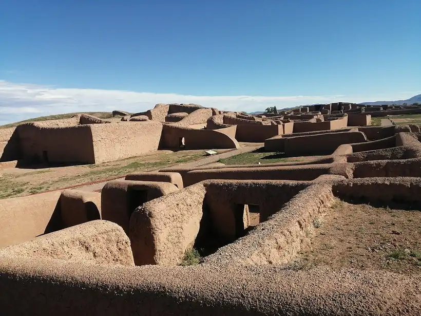
People have lived in what is now Chihuahua for more than 10,000 years. Clovis points found in the northeast are among the oldest traces, and by about 2000 BCE farmers in the north were growing maize and squash. Between roughly 1130 and 1450 CE the Casas Grandes culture built Paquimé, a town of some 2,000 adobe rooms in the valley of the Casas Grandes River. Its people raised scarlet macaws for their feathers, moved water through drains and channels, and traded with the Pueblo world to the north and with Mesoamerica to the south. Smaller settlements, such as the cliff houses of Cuarenta Casas, grew in the Sierra Madre.
Indigenous languages spoken today
Speakers aged 3 and over, census of 2020 20
INEGI's 2020 census counted 110,498 speakers aged 3 and over. INEGI's state panorama gives the two largest languages as shares of that total (Tarahumara 79.0%, Northern Tepehuán 8.9%); the counts above apply those shares to the total and are rounded. Pima and Guarijío are also spoken in the sierra.

When the Spanish arrived, the sierra and its canyons belonged to the Rarámuri, also called Tarahumara, and to Tepehuán, Pima and Guarijío communities, while Jumano, Suma and Manso peoples lived on the plains to the northeast. The Rarámuri held on to their mountain homeland through four centuries of missions, mines and railways. In 2020 the census counted 110,498 speakers of Indigenous languages aged 3 and over in the state, and about 79% of them spoke Tarahumara.
Silver towns on the northern frontier
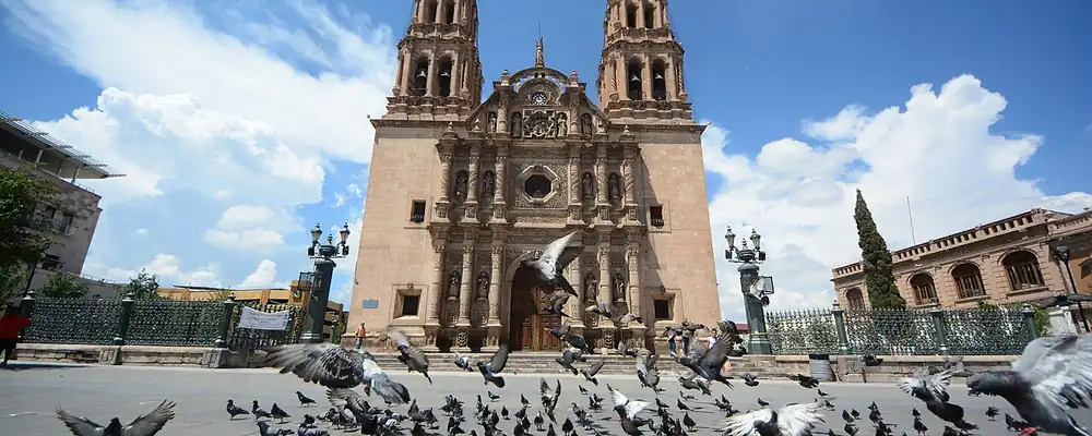
Spanish expeditions reached the region from the south. Francisco de Ibarra's men saw the ruins of Paquimé in 1566, and in 1567 settlers founded Santa Bárbara, one of the first Spanish towns in the area, in Nueva Vizcaya, the vast northern province of New Spain. In 1631 a silver strike gave rise to San José del Parral, which by 1640 had about 8,500 people. That year Philip IV named it the Capital of the World of Silver. In 1709 Antonio de Deza y Ulloa founded the mining camp that became Chihuahua City, fed by the Santa Eulalia mines; a tax on that silver paid for its cathedral.
Interactive maptap or click a state to open its page
Mining towns needed food, mules and workers, and missions and settlements spread along the river valleys around them. Jesuits entered the sierra in 1604 with a mission among the Tarahumara, and Tepehuán and Tarahumara revolts in 1616 and the 1640s, risings against the missions and forced labour, held them back. To the north, the mission founded at Paso del Norte in 1659 guarded the crossing on the route to New Mexico. Batopilas, in the canyons, became a silver town in 1708. In 1763 the crown created the Provincias Internas to defend this long frontier, and their command later settled in Chihuahua.
Places in its history
Chihuahua City
City · 1709
State capital, founded as a silver camp; Hidalgo died here and Juárez governed from here. 3
Paquimé
Archaeological site · c. 1130-1450
Adobe town of about 2,000 rooms, centre of the Casas Grandes culture. 4
Cuarenta Casas
Archaeological site · c. 1205-1350
Cliff dwellings in the Sierra Madre linked to Paquimé. 7
Hidalgo del Parral
Mine · 1631
Silver town named Capital of the World of Silver in 1640; Villa was killed here in 1923. 8
Ciudad Juárez
City · 1659
Mission at Paso del Norte, taken by the revolutionaries in 1911, later a maquiladora city. 10
Hidalgo's end, Juárez's refuge, Villa's north
Independence reached Chihuahua as an ending. Miguel Hidalgo, captured at the Wells of Baján in Mar 1811, was brought to Chihuahua City and shot there on 30 Jul 1811. Chihuahua became a state on 6 Jul 1824 and spent decades under Apache raids. In the war with the USA, Alexander Doniphan's force won at the Sacramento River on 28 Feb 1847 and occupied the capital. During the French Intervention (1862-67), while Maximilian ruled as emperor in Mexico City, Benito Juárez kept the Republic alive from Chihuahua, which served as its seat in 1864 and again from Jun to Dec 1866; Paso del Norte was renamed Ciudad Juárez in his honour in 1888.
1810 to 1920 in Chihuahua
From the timeline below, coloured by era
- 1811Miguel Hidalgo is executed in Chihuahua City on 30 Jul. 1
- 1824Chihuahua becomes a state of the federation on 6 Jul. 1
- 1847Battle of the Sacramento River, 28 Feb; USA troops occupy the capital. 11
- 1864-66Benito Juárez governs the Republic from Chihuahua during the French Intervention. 1
- 1911Orozco and Villa take Ciudad Juárez; the treaty of 21 May ends Díaz's rule. 1
Under the Porfiriato, Porfirio Díaz's rule of 1876-1911, railways reached the border and land gathered in few hands; 17 families held about two-fifths of the state. That inequality fed the Revolution. Toribio Ortega rose at Cuchillo Parado in Nov 1910, and in May 1911 Pascual Orozco and Pancho Villa took Ciudad Juárez, forcing the treaty that ended Díaz's rule. Villa's División del Norte, the army of the Villistas, made Chihuahua its base. After his 1916 raid on Columbus, New Mexico, which came after the USA had recognised his rival Carranza, a USA expedition chased him for nearly a year. Villa was killed in Parral on 20 Jul 1923.
Mennonite fields, the Chepe and the border plants
In the 20th century the economy moved from silver and cattle toward irrigated farming, railways and factories. In 1922 about 3,000 Mennonites, German-speaking Protestant farmers who left Manitoba, Canada, over its school laws, settled the Bustillos Valley near what became Cuauhtémoc, planting oats, beans and maize; the area later grew into one of the country's main apple districts. Delicias, founded in 1933 on the irrigated Conchos valley, made cotton its main crop in the 1940s. On 24 Nov 1961 the last section of the Chihuahua al Pacífico railway opened, crossing the Sierra Tarahumara with 86 tunnels and 175 bridges to reach the sea at Topolobampo.
The region, c. 1600 and today
What each state turned on, by the era table below; Chihuahua outlined in gold.
Interactive maptap or click a state to open its page
c. 1600
Chihuahua: Silver mining districts
- Silver mining districts
- Frontier: missions, presidios, independent peoples
Today
Chihuahua: Export manufacturing
- Export manufacturing
- Tourism
- Farming and agro-exports
- Mining
Its places in the modern era
Numbered as on the map above
- 7Creel · 1961
Station on the Chihuahua al Pacífico line, gateway to the Sierra Tarahumara. 15
The border changed most. After the Bracero program, the USA guest-worker scheme for Mexican farmhands, ended in 1964, Mexico launched the Border Industrialization Program in 1965 to give the returning workers jobs, and Ciudad Juárez filled with maquiladoras, plants that import parts without paying duty and export finished goods. They multiplied through the 1970s and 1980s, and in the 5 years after NAFTA took effect in 1994, maquila employment across the country rose 86%. By 2000 Ciudad Juárez had more than 300 plants.
After 2000 the border plants faced new rivals. In the downturn that began in 2001 hundreds of maquiladoras across Mexico closed as assembly work moved to China and other low-wage countries. Ciudad Juárez answered by building more: in 2007 it was absorbing more new industrial space than any other North American city, and by 2014 engineering centres such as Delphi's had joined the assembly lines. The silver camps of the 17th century drew people to the frontier, and the factories of the border have done the same; Juárez, the old crossing at Paso del Norte, remains the state's link to the USA economy.
Chihuahua, date by date
Before the Spanish before 1519
The colonial centuries 1519 to 1809
- 1566
Francisco de Ibarra's expedition reaches the ruins of Paquimé. 5
- 1567
Santa Bárbara is founded, one of the first Spanish towns in the region. 1
- 1604
Joan Font founds the first Jesuit mission among the Tarahumara. 2
- 1631
A silver strike gives rise to San José del Parral, founded 14 Jul. 8
- 1659
Franciscans found the mission at Paso del Norte, today Ciudad Juárez. 10
- 1709
Antonio de Deza y Ulloa founds the mining camp that becomes Chihuahua City, 12 Oct. 3
Independence and the Reform 1810 to 1875
The Revolution 1910 to 1920
- 1911
Orozco and Villa take Ciudad Juárez; the treaty of 21 May ends Díaz's rule. 1
Modern Mexico after 1920
- 1922
About 3,000 Mennonites from Canada settle the Bustillos Valley. 12
- 1923
Pancho Villa is killed in Parral on 20 Jul. 8
- 1961
The Chihuahua al Pacífico railway is completed on 24 Nov. 16
- 1965
The Border Industrialization Program opens the way for maquiladoras in Ciudad Juárez. 17
- 2007
Ciudad Juárez absorbs more new industrial space than any other North American city. 10
Where Chihuahua stood: c. 1600, 1910 and today
Interactive maptap or click a state to open its page
c. 1600
Silver, the heartland and the frontier
Chihuahua: Silver mining districts
- Silver mining districts
- Towns, farms and workshops of the old heartland
- Ports, sugar and cacao
- Indigenous south: cochineal, maize, tribute
- Maya lands under encomienda or beyond Spanish rule
- Frontier: missions, presidios, independent peoples
1910
The Porfiriato at its height
Chihuahua: Mining
- Mining
- Oil
- Henequén
- Sugar and textile mills
- Haciendas: grain, pulque, cattle
- Export crops: coffee, tobacco, cacao, chicle, timber
- Steel, cotton and the railway north
- Ranching frontier
- The national capital
Today
What each state turns on now
Chihuahua: Export manufacturing
- Export manufacturing
- Oil and gas
- Tourism
- Farming and agro-exports
- Mining
- Ports and logistics
- Services and government
Why Mexico's own reading of what each state's economy turned on in that period, drawn from the sources listed in each state's room; a classification, not a measurement.
Today's numbers for Chihuahua
Output, exports, jobs, wages and investment now, each with its source and date.
The bookBook 6, Where to Go in Mexico, chapter 13
Where to Go in Mexico: The Texas-Facing North, the corridor this state belongs to.
Why MexicoThe national timeline
The turning points of the whole country, each dated, each with its source.
Sources, each with its date
- Wikipedia (English), Chihuahua (state), History and Demographics sections, 3 Nov 2026 · read 3 Nov 2026 · link
- Wikipedia (Spanish), Chihuahua (estado), Historia section, 3 Nov 2026 · read 3 Nov 2026 · link
- Wikipedia (English), Chihuahua City, 3 Nov 2026 · read 3 Nov 2026 · link
- Wikipedia (English), Casas Grandes (Paquimé archaeological site), 3 Nov 2026 · read 3 Nov 2026 · link
- Wikipedia (Spanish), Paquimé, 3 Nov 2026 · read 3 Nov 2026 · link
- UNESCO World Heritage Centre, Archaeological Zone of Paquimé, Casas Grandes (list entry 560), 3 Nov 2026 · read 3 Nov 2026 · link
- Wikipedia (English), Cuarenta Casas, 3 Nov 2026 · read 3 Nov 2026 · link
- Wikipedia (English), Parral, Chihuahua, 3 Nov 2026 · read 3 Nov 2026 · link
- Wikipedia (English), Batopilas, Chihuahua, 3 Nov 2026 · read 3 Nov 2026 · link
- Wikipedia (English), Ciudad Juárez, 3 Nov 2026 · read 3 Nov 2026 · link
- Wikipedia (English), Battle of the Sacramento River, 3 Nov 2026 · read 3 Nov 2026 · link
- Wikipedia (English), Mennonites in Mexico, 3 Nov 2026 · read 3 Nov 2026 · link
- Wikipedia (English), Cuauhtémoc, Chihuahua, 3 Nov 2026 · read 3 Nov 2026 · link
- Wikipedia (English), Delicias, Chihuahua, 3 Nov 2026 · read 3 Nov 2026 · link
- Wikipedia (English), Creel-Sierra Tarahumara railway station, 3 Nov 2026 · read 3 Nov 2026 · link
- Ferrocarril Chihuahua al Pacífico (Chepe), The story of the Chepe, 3 Nov 2026 · read 3 Nov 2026 · link
- Wikipedia (English), Maquiladora, 3 Nov 2026 · read 3 Nov 2026 · link
- Tercer Censo de Población de los Estados Unidos Mexicanos 1910, Table VI, population by entity at the 1895, 1900 and 1910 censuses (digitised by Universidad Veracruzana), 1910 · read 3 Nov 2026 · link
- INEGI, Censo de Población y Vivienda 2020, results for Chihuahua (press release 56/21), 26 Jan 2021 · read 3 Nov 2026 · link
- INEGI, Panorama sociodemográfico de Chihuahua, Censo de Población y Vivienda 2020, 2021 · read 3 Nov 2026 · link
Pictures
- Catedral de Chihuahua, Plaza de las Armas, Chihuahua- Chihuahua cathedral (24256572941): Comisión Mexicana de Filmaciones from México D. F., México, CC BY-SA 2.0, Wikimedia Commons · read 3 Nov 2026
- Zona arqueológica de Paquimé 2020: Levi bernardo, CC BY-SA 3.0, Wikimedia Commons · read 3 Nov 2026

Where the sources disagree
- Santa Bárbara: Wikipedia (English) gives 1567 as the founding year; Wikipedia (Spanish) gives 1564. This page uses 1567.
- Paquimé: Wikipedia (English) gives settlement after 1130 and abandonment c. 1450; Wikipedia (Spanish) gives occupation from c. 700 and abandonment c. 1340; UNESCO, 700-1475. This page uses c. 1130-1450.
- Parral: Wikipedia (English), in its state article, calls Parral the world's largest silver producer in 1640; its Parral article says it was not the most lucrative northern mine. This page uses only the 1640 title.
Chiapas
Maya and Zoque cities, three centuries ruled from Guatemala, its own choice to join Mexico in 1824, then coffee, great dams and the uprising of 1994.
All 32 on the mapNext →Mexico City
From Cuicuilco and the island of Tenochtitlan to the capital of New Spain, the Federal District of 1824 and the vast metropolis renamed Mexico City in 2016.