State of Mexico
Teotihuacan, the Matlatzinca and Mazahua valleys, early silver and pulque, a great state cut down to size, then the factory belt and new cities around the capital.
Capital: Toluca · Became a state: 1824 · Checked 3 Nov 2026
Interactive maptap or click a state to open its page
State of Mexico in figures from its history
Teotihuacan and the peoples of the valleys
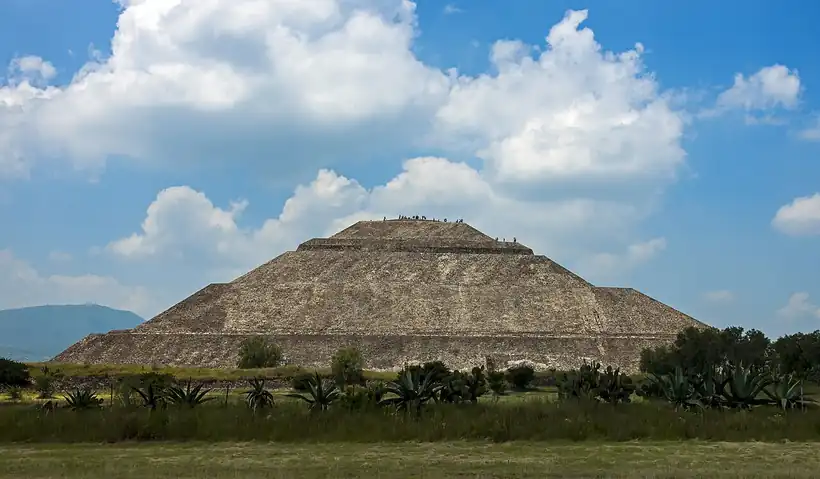
People reached the Valley of Mexico very early; a quartz scraper and an obsidian blade from Tlapacoya are dated to about 20,000 years ago. Pottery appears around 2500 BCE at sites such as Tlatilco. Teotihuacan, founded around 100 BCE in the northeast of today's state, became one of the largest cities of its age, with perhaps 100,000 people around 450 CE. Its Pyramids of the Sun and the Moon still stand, and the city was abandoned around 750.
Indigenous languages spoken today
Speakers aged 3 and over, census of 2020 5
417,603 people aged 3 and over spoke an Indigenous language in 2020 (2.6%). The state's own small languages are Tlahuica (2,178 speakers) and Matlatzinca (1,076).

West of the mountains, the Matlatzinca ruled the Toluca Valley, a land of maize, from Teotenango from about 800 CE and later from Calixtlahuaca. Otomí people were centred at Jilotepec and the Mazahua near the Jocotitlán volcano. In the east, Texcoco was the Acolhua capital of Nezahualcóyotl (1402-1472), poet-king and ally of the Mexica. In the 1470s the Mexica ruler Axayácatl conquered the Toluca Valley and took 11,070 prisoners in a single battle; Malinalco fell in 1476 and its rock-carved temple dates from 1501. These peoples remain. Mazahua is the most spoken Indigenous language in the state, followed by Otomí and Nahuatl, and small communities still speak Tlahuica and Matlatzinca.
Silver, pulque and the missions
Gonzalo de Sandoval led the Spanish conquest of the Toluca Valley in 1521, and the conquistadors divided its towns in encomiendas, grants that gave Spaniards the tribute and labour of Indigenous towns. Texcoco had already served the conquest: the brigantines that attacked Tenochtitlan were launched there on 28 Apr 1521. Franciscans, Dominicans and Augustinians followed. Pedro de Gante founded a school for Indigenous students at Texcoco, and the Augustinians built their monastery at Malinalco between 1540 and 1560. At Tepotzotlán the Jesuits arrived in 1580 and from 1585 trained priests in the college of San Francisco Javier, until their expulsion in 1767.
Interactive maptap or click a state to open its page
The colony lived mainly from farming, but the south held silver. Spaniards found silver lodes at Sultepec in 1531, and amalgamation, refining the ore with mercury, was in large-scale use there by 1556; Sultepec and Amatepec were known together as the Province of Silver. Temascaltepec, Zacualpan and Tlatlaya were also mined. In the north, Otumba and Texcoco produced pulque, the fermented drink of the maguey. Much later, in 1787, miners founded El Oro, whose gold veins would carry the state's mining into the 20th century. The work fell on Indigenous villages, and most of the population lived in deep poverty.
Places in its history
Teotihuacan
Archaeological site · c. 100 BCE-750 CE
The Pyramids of the Sun and Moon; a World Heritage Site since 1987. 6
Malinalco
Archaeological site · 1476; 1501; 1540-60
Mexica temple cut from the rock above the town, and an Augustinian monastery below. 9
El Oro
Mine · 1787-1958
Gold town of British-backed mines, rail station 1899, last mine closed 1958. 12
Tepotzotlán
Mission · 1580-1767
Jesuit college of San Francisco Javier, now the National Museum of the Viceroyalty. 13
Ciudad Nezahualcóyotl
City · 1963
City built on the drained bed of Lake Texcoco, past 1 million people by 1995. 15
A great state cut down to size
On 30 Oct 1810 Hidalgo's insurgents defeated the royalists at Monte de las Cruces, in what is now Ocoyoacac, then turned back without taking Mexico City. The State of Mexico was declared free and sovereign on 1 Feb 1824, one of the largest of the new federation. It soon lost its heart, because the new republic wanted its capital under federal control: the capital city became the Federal District in Nov 1824, and the state government moved to Texcoco, then to Tlalpan in 1827 and, for good, to Toluca in 1830. More territory went to form new states: Guerrero on 27 Oct 1849, Hidalgo on 15 Jan 1869 and Morelos on 17 Apr 1869.
1810 to 1920 in State of Mexico
From the timeline below, coloured by era
- 1810Insurgents win at Monte de las Cruces on 30 Oct. 14
- 1824The State of Mexico is declared free and sovereign on 1 Feb. 2
- 1830Toluca becomes the permanent state capital. 2
- 1849The state of Guerrero is created from its southern lands on 27 Oct. 2
- 1869Hidalgo (15 Jan) and Morelos (17 Apr) are created from its territory. 2
- 1915Toluca hosts the Convention of revolutionary generals and governors. 1
During the war with the USA, invading troops occupied Toluca and the state government took refuge in Sultepec. In the Reform War of 1858-61, the civil war between liberals and conservatives over the Reform laws that sold off Church and communal lands, the liberals Melchor Ocampo, Santos Degollado and Leandro Valle were shot in the Toluca Valley. During the Porfiriato, Porfirio Díaz's rule of 1876-1911, the mines reached their highest output; at El Oro, British capital and the Esperanza vein drew new settlers, and a railway station opened in 1899. In the Revolution, Zapatistas, Emiliano Zapata's peasant army, under Genovevo de la O fought in the southwest from 1912, and in 1915 Toluca twice hosted the Convention of revolutionary generals and governors.
From mines to the factory belt of the capital
The mining age ended slowly. At El Oro several mines cut production in 1926, the companies were expropriated from their British owners in 1937, and the last mine, Dos Estrellas, closed in 1958. Industry took its place. In 1940 the industrial zone of Naucalpan opened and began the spread of the Mexico City metropolitan area into the state. Toluca grew as an industrial centre from 1944; the Toluca-Lerma-Tianguistenco industrial zone began attracting firms in 1965, and Chrysler has built cars in Toluca since 1968. To supply the capital, water was piped from the Lerma River basin, and highways tied the state to the rest of the country.
The region, c. 1600 and today
What each state turned on, by the era table below; State of Mexico outlined in gold.
Interactive maptap or click a state to open its page
c. 1600
State of Mexico: Towns, farms and workshops of the old heartland
- Silver mining districts
- Towns, farms and workshops of the old heartland
- Ports, sugar and cacao
Today
State of Mexico: Export manufacturing
- Export manufacturing
- Oil and gas
- Tourism
- Farming and agro-exports
- Services and government
Its places in the modern era
Numbered as on the map above
- 7Ciudad Nezahualcóyotl · 1963
City built on the drained bed of Lake Texcoco, past 1 million people by 1995. 15
The fastest change came on the drained bed of Lake Texcoco. Migrants settled there in growing numbers, from about 2,000 people in 1949 to about 80,000 in 1960. The municipality of Nezahualcóyotl was created in 1963, and by 1995 it had passed 1 million inhabitants. Other settlements followed around the capital's northern and eastern edges. By the census of 2020, the State of Mexico had 16,992,418 people, more than any other state, against 934,463 in 1900.
The Arco Norte toll road, begun on 28 Feb 2006 and opened in stages from 2009 to 2011, carries traffic around the metropolis. After a 2018 referendum on the unfinished airport at Texcoco, the federal government turned the Santa Lucía air base at Zumpango into the Felipe Ángeles International Airport, which opened on 21 Mar 2022, 35 km north of the capital. The El Insurgente interurban train, 57.7 km long, opened its first section between Zinacantepec and Lerma on 15 Sep 2023 and reached Mexico City on 2 Feb 2026. The state that lost its capital in 1824 now holds much of the capital's growth.
State of Mexico, date by date
Before the Spanish before 1519
- c. 2500 BCE
Pottery appears at Tlapacoya, Tlatilco and other sites. 1
- c. 100 BCE
Teotihuacan is established; it peaks around 450 CE. 6
- c. 800
The Matlatzinca rule the Toluca Valley from Teotenango. 1
- 1474-78
The Mexica under Axayácatl conquer the Toluca Valley. 8
- 1501
The Mexica carve the temple of Malinalco from the living rock. 9
The colonial centuries 1519 to 1809
Independence and the Reform 1810 to 1875
- 1810
Insurgents win at Monte de las Cruces on 30 Oct. 14
- 1824
The State of Mexico is declared free and sovereign on 1 Feb. 2
- 1830
Toluca becomes the permanent state capital. 2
- 1849
The state of Guerrero is created from its southern lands on 27 Oct. 2
- 1869
Hidalgo (15 Jan) and Morelos (17 Apr) are created from its territory. 2
The Revolution 1910 to 1920
- 1915
Toluca hosts the Convention of revolutionary generals and governors. 1
Modern Mexico after 1920
- 1940
The Naucalpan industrial zone begins the metropolitan spread. 1
- 1958
Dos Estrellas, the last mine at El Oro, closes. 12
- 1963
The municipality of Nezahualcóyotl is created on the old lakebed. 15
- 1965
The Toluca-Lerma-Tianguistenco industrial zone begins attracting firms. 7
- 2022
The Felipe Ángeles International Airport opens at Zumpango on 21 Mar 2022. 17
- 2023
The El Insurgente interurban train opens its first section, Zinacantepec-Lerma, on 15 Sep 2023. 18
Where State of Mexico stood: c. 1600, 1910 and today
Interactive maptap or click a state to open its page
c. 1600
Silver, the heartland and the frontier
State of Mexico: Towns, farms and workshops of the old heartland
- Silver mining districts
- Towns, farms and workshops of the old heartland
- Ports, sugar and cacao
- Indigenous south: cochineal, maize, tribute
- Maya lands under encomienda or beyond Spanish rule
- Frontier: missions, presidios, independent peoples
1910
The Porfiriato at its height
State of Mexico: Haciendas: grain, pulque, cattle
- Mining
- Oil
- Henequén
- Sugar and textile mills
- Haciendas: grain, pulque, cattle
- Export crops: coffee, tobacco, cacao, chicle, timber
- Steel, cotton and the railway north
- Ranching frontier
- The national capital
Today
What each state turns on now
State of Mexico: Export manufacturing
- Export manufacturing
- Oil and gas
- Tourism
- Farming and agro-exports
- Mining
- Ports and logistics
- Services and government
Why Mexico's own reading of what each state's economy turned on in that period, drawn from the sources listed in each state's room; a classification, not a measurement.
Today's numbers for State of Mexico
Output, exports, jobs, wages and investment now, each with its source and date.
The bookBook 6, Where to Go in Mexico, chapter 16
Where to Go in Mexico: The Center, the corridor this state belongs to.
Why MexicoThe national timeline
The turning points of the whole country, each dated, each with its source.
Sources, each with its date
- Wikipedia (English), State of Mexico, History section, 3 Nov 2026 · read 3 Nov 2026 · link
- Wikipedia (Spanish), Estado de México, Historia section, 3 Nov 2026 · read 3 Nov 2026 · link
- INEGI / 1910 census, Table VI, population of the federal entities in 1895, 1900 and 1910 (Universidad Veracruzana transcription), 1910 · read 3 Nov 2026 · link
- INEGI, 2020 Census, State of Mexico population as cited by Wikipedia (English), State of Mexico, 3 Nov 2026 · read 3 Nov 2026 · link
- COESPO Estado de México, Población indígena del Estado de México (2020 Census data), Mar 2021 · read 3 Nov 2026 · link
- Wikipedia (English), Teotihuacan, 3 Nov 2026 · read 3 Nov 2026 · link
- Wikipedia (English), Toluca, 3 Nov 2026 · read 3 Nov 2026 · link
- Wikipedia (English and Spanish), Calixtlahuaca, 3 Nov 2026 · read 3 Nov 2026 · link
- Wikipedia (English), Malinalco, 3 Nov 2026 · read 3 Nov 2026 · link
- Wikipedia (Spanish), Texcoco de Mora, 3 Nov 2026 · read 3 Nov 2026 · link
- Wikipedia (English), Sultepec, 3 Nov 2026 · read 3 Nov 2026 · link
- Wikipedia (English), El Oro de Hidalgo, 3 Nov 2026 · read 3 Nov 2026 · link
- Wikipedia (English), Tepotzotlán, 3 Nov 2026 · read 3 Nov 2026 · link
- Wikipedia (English), Battle of Monte de las Cruces, 3 Nov 2026 · read 3 Nov 2026 · link
- Wikipedia (English), Ciudad Nezahualcóyotl, 3 Nov 2026 · read 3 Nov 2026 · link
- Wikipedia (English), Arco Norte, 3 Nov 2026 · read 3 Nov 2026 · link
- Wikipedia (English), Felipe Ángeles International Airport, 3 Nov 2026 · read 3 Nov 2026 · link
- Wikipedia (English), El Insurgente (Mexico City-Toluca interurban train), 3 Nov 2026 · read 3 Nov 2026 · link
Pictures
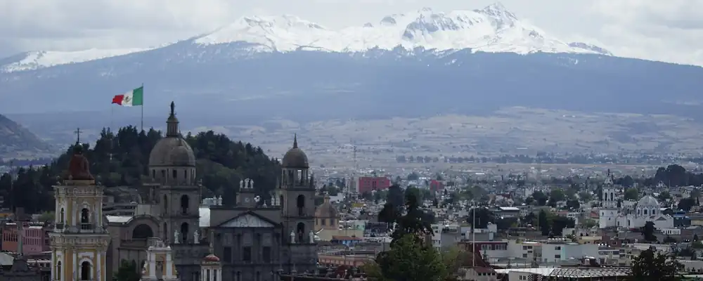
- Toluca a los pies del nevado: HernanLuna, CC BY-SA 3.0, Wikimedia Commons · read 3 Nov 2026
- Pyramid of the Sun, Teotihuacan, from path to parking lot: Daniel Case, CC BY-SA 3.0, Wikimedia Commons · read 3 Nov 2026

Where the sources disagree
- Toluca as a Spanish town: Wikipedia (English) says a Spanish community was established in 1530; a source it cites marks the city's 500th anniversary in 2022, implying 1522. This page uses 1530.
- Statehood: Wikipedia (English and Spanish) give 1824; Wikipedia (English, Toluca) gives 1825. This page uses 1824.
- Capital at Texcoco: Wikipedia (English) says the government moved there in Nov 1824; Wikipedia (Spanish, Texcoco de Mora) says it was named capital on 4 Jan 1827. This page gives Texcoco, then Tlalpan 1827, then Toluca 1830.
Jalisco
From the round temples of the Teuchitlán valleys to the factories of Guadalajara, Jalisco grew from the frontier of Nueva Galicia into the heart of western Mexico.
All 32 on the mapNext →Michoacán
From the Purépecha kingdom that held off the Aztecs to the birthplace of Morelos and the dams of the Balsas, Michoacán has shaped Mexico on its own terms.